Monday, May 20, 2013

End of the Road (for now)


It is an easy trip from Vero Beach to St. Augustine on the ICW, taking three days with two nights at anchor along the way.  This is northern Florida where large homes and water front communities are interspersed with nature preserves.  You can go for miles in the company of dolphins, birds and manatees without seeing any development.  The ocean is often just over the dunes to the east.  In all, it is a pleasant experience, reinforced by the knowledge that the current sea conditions in the Atlantic Ocean make that a less desirable alternative.

We reach St. Augustine early afternoon and launch the dinghy so that we can enjoy a brief visit to this historic and attractive city.  To celebrate our last night in Florida, we have dinner at a nearby restaurant with friends we know from the Bahamas.  They are in St. Augustine to store their boat for the summer.  And this isn’t too unusual as our group of Bahamas cruisers are falling by the wayside, most storing their boats in southern locations.  We are in the minority as full time liveaboards, heading as far north as possible. 

After dinner, it is time to prepare the boat for the offshore passage.  The dinghy is secured to the deck, jacklines installed, and the engine gets a thorough check up.  The weather for our passage is looking favorable, and we will leave at first light in the company of friends on another sailboat who are veterans of two circum-navigations and one trip to Europe and back.  It humbles us when we encounter such people. 

The next morning is beautiful, and we head out into the Atlantic with a parade of boats.  Most will peel off somewhere along the coast for shorter hops, but our two boats are determined to make it all the way to Beaufort, NC. The waves are almost non-existent, the sky is blue, and we begin a long motorsail northward. We will be at sea for three days and two nights.  One truism of sailing is that if anything will go wrong, it will happen at night.  This proves to be the case for us.  In the middle of our first night out, while I am on watch, the prop suddenly begins to make a very ugly noise, actually shaking the boat.   In a panic I shift to neutral and the noise stops.  Burt comes on deck, and we think through the situation. There seem to be two possibilities; either the zinc on the prop has come loose or we have hit something that perhaps is tangled in the prop.  We cautiously put the engine in reverse – no ugly noises.  Then we try minimum RPM’s in forward and still no ugly noises.  We eventually get the nerve to go back to cruising speed and everything is operating just fine.  The downside to bump in the night events is that your adrenaline is now sky high and neither of us gets much sleep for the rest of the night. We will hire a diver once we get to Beaufort to verify that nothing is wrong below the waterline.

Things go just fine until the following night.  Just after I begin my watch, I see flares going off in the distance.  I call over to our buddy boat and ask if they have seen anything, but they were below at the time.  Over the next few minutes several more flares go off.  I take note of our position at the time and take a sight bearing in the direction of the flares.  We are about 50 miles off the coast and barely in range of the Coast Guard when I call in our observations.  More flares are going off while I answer what seems to be hours of inane questions, often relayed by our buddy boat since they are receiving the radio communications better than we are.  At the same time, another boat, perhaps 20 miles away from us is also reporting the flares and with their position and sight bearing, it seems the Coast Guard could figure out the location of the activity.  But, the poor soul on duty that evening is having some difficulies.  Finally, hr requests that we alter our course and begin a Search and Rescue Operation.  I am not too thrilled about this as we have no idea how much further offshore we need to head, but we comply with the request.  After all, if we were the boat in danger, we would hope others would be willing to come to our assistance.   It all ends when the Coast Guard contacts us again with the news that the flares we have been seeing are actually a naval training exercise.  We are amazed that it took over a half an hour to identify the source.  We go back to our intended course, but it is another night where adrenaline is pumping and again we get little sleep.  We pull into Beaufort around noon on the third day after covering 384 nautical miles in 58 hours.  We are exhausted and splurge on a dock along the town waterfront. 
Burt relaxes in the hammock-chair along the Beaufort waterfront


Now, we shy away from docks due to the expense. We actually have not been at a dock since we checked into the Bahamas in Nassau in early February. But, this time it appears it will be an interesting and enjoyable experience.  We are told to pull into the slip next to the sailboat with the 100 foot mast. It doesn’t take long until we meet the captain and crew of our neighbor, an Oyster 72 out of England.  They are the paid crew, a husband and wife from Britian and the Netherlands, respectively, and now residents of British Columbia.  They are friendly and are looking for some company for the evening. We make arrangements to join them for a drink and dinner ashore and include the couple on our buddy boat. It makes for an interesting conclusion to the day as our companions have sailed all over the world.  We listen spellbound to what they have done and experienced and stop for a cup of expresso on the Oyster before calling it a night.  As the evening ends, we find that all of us have cruising friends in common.  In the sailing community seems to exemplify “one degree of separation” with those we encounter, and we plan to stay in touch with this interesting couple.

The next morning the Oyster leaves as they are making an ocean passage all the way to Maine where the boat is undergoing six weeks of maintenance.  In its place a 146 foot motor yacht pulls in, and we now are looking out at a very BIG white wall. It appears things will remain interesting.  Again, this is a delivery crew, also taking this boat up to Maine.  Once the boat is docked and cleaned from top to bottom by the large, uniformed crew, the captain stops by to chat.  He is retired from the Coast Guard, and this is his full time job. The boat winters in Florida and New Orleans (we suspected that when we saw a Saints Super Bowl Flag on the bow staff) and summers in Maine where the owner uses it for about six weeks in June and July, before he heads back to work in August.  And why would he need to be at work in August?  Perhaps, because he is the owner of the New Orleans Saints and a pro basketball team.  Sometimes the wealth we observe is astounding. 
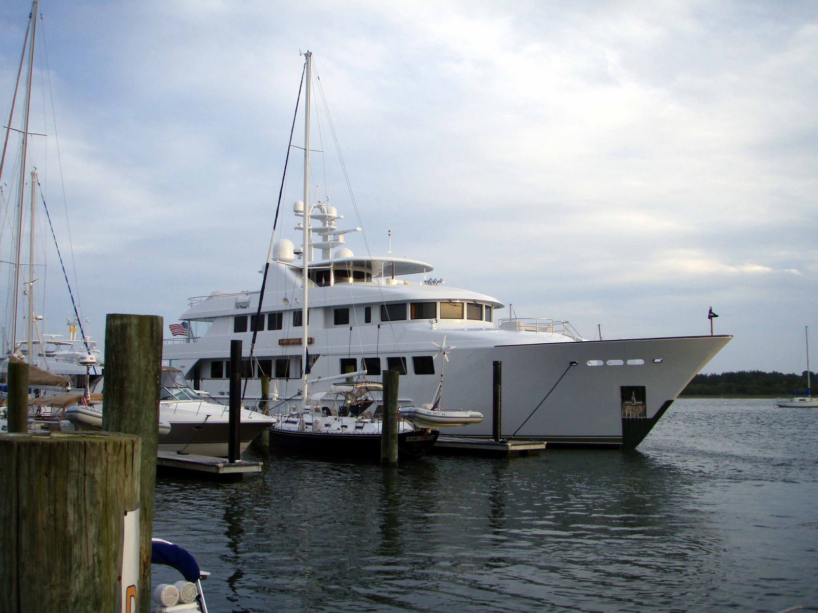
Laady Gayle Marie docked next to our tiny boat


Once we have gotten some well deserved sleep and are done gawking at our neighbors, we take the dinghy to do some exploring around Beaufort.  The small town sits on the mainland and is separated from the ocean by a series of barrier islands that are part of a national seashore.  We take the dinghy to one of the islands and go on a hike.  But we see little; our eyes are glued to the foot path as we try to avoid large piles of horse manure. You see, these islands are all populated by herds of wild horses.  We dinghy to another section of the island where we find some of the horses knee deep in water, grazing on the marsh grasses.  
Wild horses grazing in the marshes

Marsh land separating the numerous barrier islands
 The area is named the Rachel Carson Wildlife Preserve in honor of Carson’s years spent studying the ecology of the area. 

Later that afternoon we venture over to the annual Beaufort Music Festival, just down the waterfront from our dock. While we can hear the music on the boat, it is fun to mingle with the crowd.  A variety of North Carolina groups are featured during this two day event.

We would love to stay in Beaufort, one of our favorite coastal towns, but we are on a tight schedule.  North winds are predicted so we will make the remainder of the trip to the Chesapeake on the ICW instead of tempting fate along Cape Hatteras. We spend three days motoring through sparsely populated swamp lands.  There are few towns along the way and almost no cell phone service.  We anchor alone in remote locations for the two nights underway before heading into the Norfolk area that bustles with activity.  There we dodge commercial and military traffic, and transit a lock and many opening bridges on restricted schedules, thus making this final leg to the Chesapeake a bit slower. 
The USS Comfort docked at Norfolk, a symbol of America's generosity around the world

One of the large aircraft carriers with a jet visible on the deck

Once free of Norfolk, it is time to unfurl the sails and head north up the Bay. Our first night’s anchorage is at Deltaville where we spent a month last spring doing maintenance.  
The serene anchorage at Deltaville

 The next night we pull into Solomon’s Island, where in previous visits we have anchored in an adjacent creek.  This time we decide to take a mooring ball for two nights and explore the town. The place is full of marinas and boatyards, probably because it provides easy access to the Bay for Washington, DC residents.  There are a few bars and restaurants along the waterfront, and right next to the mooring field is a very nice maritime museum which we visit.   
The maritime museum at Solomon's Island with its iconic screwpile lighthouse

That night the museum is sponsoring an outdoor concert, one of their major fund raisers for the year, featuring A Band Called Perry, a nationally known country band.  Five thousand fans have purchased pricy tickets, but we sit on the back deck of the boat enjoying the music and light show for free.  Yes, it is not quite as loud for those of us on a mooring, but that’s just fine by us.

One last breezy and rainy sail brings us to Galesville, MD and the Hartge Yacht Harbor.  Here we will pull the boat, leaving it on the hard while we head back to Ohio and Wisconsin to visit family and do annual doctor checkups.  We have routine maintenance, varnish work, serious cleaning and polishing, recertification of our life raft, and installation of a new autopilot to accomplish once we return. So, it will be about a month until Exuberant is back underway and heading further north. We reflect back on our recent travels – not counting the days spent waiting for acceptable weather, we have covered almost 1100 nautical miles in thirteen days since we left Green Turtle Cay in the Bahamas. No wonder we are feeling a bit tired.

Saturday, May 4, 2013

Twiddling Our Thumbs in the Abacos


We’ve got a couple of weeks to spend in the Abacos, and that isn’t a hard thing to do.  People often compare the Abacos with South Florida.  It has many ex-pat vacation homes, ranging from cottages to mansions, plenty of comparatively upscale resorts, and more amenities than we’ve seen since arriving in the Bahamas.  Our time is divided between cruising the barrier islands and dropping into Marsh Harbor for shelter during stormy weather.  Since we are a deep draft boat, there are very few places for us to hide when a storm hits, so we find ourselves in and out of our little pocket of deep water in Marsh Harbor. In the span of two weeks we have had several fronts come through, giving us a total of eight inches of rain. It is safe to say we are no longer salt incrusted.

During periods of settled weather we go island hopping.  Sunday is a must at Nipper’s on Guana Cay.  Everyone, Bahamians and visitors alike,  makes an appearance, and the deck and two pools are packed with party-goers. It’s loud with a DJ belting out Bahamian and American tunes.  
 
The Sunday afternoon action at Nipper's
 After a while, a stroll along the ocean beach makes a nice break from the chaos. Later we walk back to the inside beach where we have left our dinghy and meet up with some British friends we had originally met in Miami at Christmas. We stop at another beach bar, Grabbers, for a light dinner.  Before long some of the overflow from Nipper’s show up, nicely lubricated from the earlier festivities, and the action, even at quiet Grabbers, gets going again.

Hopetown is one of our favorite cays in the Abacos; it is what you might call cute.  The village is full of older restored cottages painted bright colors.   
The new Hopetown Marina, done in a style typical of the village

There are souvenir shops and waterfront bars. We have to anchor far out due to the depths, but the weather is settled so the distance is no problem.  One day we take the dinghy the entire length of Elbow Cay, the island on which Hopetown is located.  Along the way we see newer, huge mansions and docks with large yachts – foreign money is plentiful here and the locals seem to be flourishing from the infusion of cash.  At the end of Elbow Cay, we come to Tahiti Beach, a sand bar that extends a ways off shore.  It is a fun place to explore at low tide, and today it is populated by many families as the waters are so kid friendly.   
Exploring the sand bar at Tahiti Beach on Elbow Cay

Walking along the sand bar, Burt finds a small starfish. Upon turning it over, we see the claw of an even smaller crab protruding from its “mouth”. It looks like this starfish had a pretty nice breakfast today. 
Starfish consuming a crab - the last claw is sticking out of its "mouth"

Another day, we take our bikes and ride the length of Elbow Cay on a decently paved road.  Again, we see million dollar homes perched on the barrier dunes and make a brief stop at the well known and lovely Abaco Inn. 
The beautiful oceanside pool at the Abaco Inn

But, our favorite stop is at the pool side bar/restaurant at the Hopetown Harbor Inn.  Overlooking the ocean, we sit by the beautifully landscaped pool and enjoy lunch and drinks.   
The gardens and pool side dining at the Hopetown Harbor Inn

Once revived, we climb down the stairs to the mile long beach for a stroll in the breaking waves.  Hurricane Sandy made a direct hit at this spot, and the beach has eroded since we were here last year, but no one seems too concerned – sand comes and sand goes, and it looks like the beach is beginning to fill in again. 
What remains of the beach at Hopetown

  Another day we take the boat further south in the Sea of Abaco to an area administered by the national parks.  Here, at Sandy Cay, there are mooring buoys for dinghies and some of the best snorkeling in the Bahamas.  The coral is exceptionally healthy and small, colorful reef fish are abundant. Since the water is unusually warm, we can spend most of the afternoon swimming. During the time we are snorkeling, we see eleven large spotted eagle rays swimming with the current. Between the clear water and their graceful movements, it appears they are flying and gliding through air. As there is an ocean swell where we have anchored Exuberant, we move over to the protection of isolated Taloo Cay for a restful night.

While we have been in the Abacos, we have experienced a succession of weather fronts passing through with remarkable quantities of rain.  Now, we see a break in the pattern and start positioning ourselves to leave for the States.  It is a flat calm day as we motor across the Sea of Abaco.  In depths averaging 15 feet we can see every blade of grass and a bounty of starfish on the bottom.  
Star fish on the bottom in the Sea of Abaco - the water clarity is amazing on a calm day

 We pass through the Whale Cut, an area often known for crashing waves along the boundary where the Sea of Abaco meets the Atlantic Ocean.  Today it is almost calm, and we make it through easily, anchoring in the lee of Green Turtle Cay.  We have plenty of time to explore the White Sound area of the cay, stopping for Happy Hour at a lovely, restored resort.

The next day we plan to explore the settlement of New Plymouth, but the weather reports indicated that we should begin our trip north.  Our original destination was to be Beaufort, NC, but over the course of the day that is shortened to Charlestown, SC, then St. Augustine, FL, then Cape Canaveral, FL, and finally Ft. Pierce, FL – the weather just isn’t being very helpful. As we head east across the Little Bahama Banks, we are joined by at least twenty other boats.  Some plan to overnight in the protection of Great Sale Cay, while others, including us, have decided to head directly to Ft. Pierce through the night.  It is a gorgeous full moon night with just a hint of wind. Many of the stars are obscured by the bright moonlight, and we can always make out the horizon.  It is calm enough that we sail for a while with just the jib while barbecuing steaks on the back deck.  In the middle of the night, we slip off the banks into the deep ocean waters and by sunrise find ourselves in the Gulf Stream which is much bouncier than expected. Forty miles of queasy stomachs later we are free of the confused seas, and several hours after that we make our way into the Ft. Pierce Inlet. 

We have arrived back in the States and life should be easy, but it is not working out quit that way.  We have something called a Local Boater’s Option Card which allows us to clear into the States by phone.  As we are coming in, we make the call, but the agent says we need to be at a dock to clear in.  We can’t do that as there are no marinas in Ft. Pierce with sufficient depth for Exuberant, so we agree to anchor off a marina and make our call.  This should be a quick transaction, so we drop the anchor with minimal scope and without backing it down, and turn off the engine to comply with the requirement of being anchored.  Once we get the clearance, we attempt to start the engine but nothing happens. We are now poorly anchored off a busy channel with strong currents and have no way to move to a better location or do a better job of anchoring.  Burt quickly checks obvious causes of our problem but finds nothing.  At that point, we launch the dinghy off our deck, attach the outboard, and tie it to the side (hip) of Exuberant. This way, if we get in an emergency situation, we might be able to control the boat with the power of the dinghy.  Meanwhile, friends have pulled in behind us and are offering suggestions for trouble shooting, staying the night for moral and perhaps other support.  After tracing wiring and checking electrical draws, Burt finds that the ignition switch has gone bad.  He removes it from the panel and works on it for several hours until he can get some voltage through it.  Over the years water has gotten into the switch and corroded the mechanism. The next morning, our fingers crossed, we start the engine up with the jerry rigged ignition and head north twelve miles to the mooring field in Vero Beach, a protected harbor where we will stay until a new switch arrives.  We feel very fortunate that this failure occurred in the States and not in some remote location in the Bahamas.

In the meantime, the hoards of boats that have also crossed over from the Bahamas are gathering in Vero Beach.  It is like a grand homecoming with everyone discussing their winter’s adventures.  There are meals out at local restaurants, happy hours, and visits with friends who are CLOD (Cruisers Living on Dirt – ex-cruisers who have taken up residence in Vero).  Cruising friends from Annapolis who have just purchased a condo near the marina invite us over to see their new digs. And we meet new cruising friends including a couple from Turkey who now keep their sailboat in the States since crossing the Atlantic several years ago. We take one afternoon to bicycle through some of the nicer Vero neighborhoods, admiring the lush tropical landscaping, probably thanks to the incessant rain.  Besides all the fun, we get much accomplished during our stay. With torrential rains almost every day (around 10 inches in eight days) the salt accumulations have been power washed off the boat.  Burt polishes the hull and stainless. I do eleven loads of wash, including much of our interior cushions and bedding, all of which have become a bit salty over the months.  We have access by a free bus to do a lot of shopping, replacing ship stores that have been depleted. During the time we are in Vero the recurrent storms are making the ocean impassible, much to the local surfers’ delight. Waves are reported eighteen feet high in the Gulf Stream. We will stay in Vero, bailing the dinghy on a daily basis, until this unseasonable weather finally clears.

We are now into early May when we had assumed we would be much further north. We finally get the word that conditions will improve during the second week of May.  We decide to start up the ICW towards St. Augustine. In the distance, we see the line of storm clouds out over the Gulf Stream, but it is mild along the waterway. In the three days it will take to reach St. Augustine, the ocean should finally settle, and we hope to make a long passage between St. Augustine and Beaufort, NC where we can easily rejoin the ICW. Our fingers are crossed as this has been a winter of changeable weather that often alters our plans at the last minute.

And did we mention that it is windy in the Bahamas? This is a picture of our now retired Bahamian courtesy flag.  It is/was an unusually durable flag, and you can see what remains of it after three months in a stiff breeze. 
The remains of our Bahamian courtesy flag after three months of cruising