Thursday, August 29, 2013

Late Summer Change of Direction


We’ve been in Maine for almost a month, but we start to sense a change of seasons.  Dry leaves begin to scatter on the ground, and a few of the trees are showing a little color.  Fall comes early to Downeast Maine, and we are getting the message that it is time to head southwest.

We are not rushing though, but rather taking time to hop 
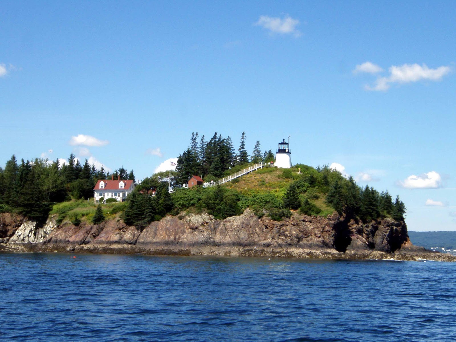
through the islands, visiting harbors that are new to us.  First stop is Buckle Harbor on Swan Island.  It is remote and difficult to enter, but we are rewarded with a protected anchorage with only a few other boats and glorious views back to the mountains of Acadia. 
The view from Buckle Harbor - we're not that far from Acadia at this point


The next day takes us through the Deer Island Thoroughfare to an anchorage amongst the small islands of Merchant Row.   
One of the Camden schooners plies the waters of the Thoroughfare - look closely at all the d___ lobster pots

We tuck in between Camp Island and the colorfully named Devil’s Island and Hell’s Half Acre. Come low tide a multitude of rocky islets and ledges appear – after all we are in the land of ten foot tides.  We delight in climbing around this pink granite playground. The area is known for its granite quarries which have supplied the building materials for many famous buildings and bridges in Boston and New York City. 
A vista over the Camp Island anchorage

Burt tests his strength on the rocky shore at Camp Island
About a mile away by dinghy is the town of Stonington. This is an interesting place if you are intrigued by lobsters.  Stonington has the distinction of supplying more lobsters to market than any other port in Maine.  Three large piers dominate the waterfront with trucks and cranes carting away the day’s catch. While located on the south side of Deer Island, there is a bridge connecting the north side of the island to the mainland, thus allowing easy transportation of the catch to the northeast and world markets. And if there is any question about priorities, lobster boats get the moorings closest to town, other commercial boats come next, and pleasure boats are at the far extremes.  
Stonington's working waterfront

Looking back at Stonington at low tide
The place rings with authenticity, and it is here that Burt purchases a very interesting book on the anthropology and sociology of the lobstering industry.
Looking down one of the side streets in Stonington


Our next hop takes us to an anchorage near North Haven on an island of the same name.  In contrast to Stonington, North Haven’s heritage evolves from summer residents.   
An interesting house at North Haven that is said to emulate a ship

There are few lobster boats in the harbor, but rather a sizable fleet of historic wooden racing dinghies. We stroll through the town and dinghy along the waterfront.  
North Haven's not so working waterfront

Back at our anchorage, a creek meanders off the bay.  It is a protected hurricane hole with a number of local boats moored inside along with a very stylish houseboat. The entire shoreline is unoccupied conservancy land. 
A well maintained houseboat in an idyllic anchorage


Enough poking around – we head back to Camden for a day of laundry and grocery shopping utilizing the marina’s courtesy car, a luxury that I could easily become accustomed to. The next day we position ourselves at Tenants Harbor for the following day’s 24 hour passage to Provincetown. The entrance to the harbor is guarded by the extensive compound belonging to Jamie Wyeth. 
Jamie Wyeth's island at the entrance to Tenants Harbor - he has restored the historical lighthouse on the island

The surrounding barren topography is indicative of the settings of so many of Jamie’s and Andrew’s paintings. Tenants Harbor is a bit of a backwater lobstering village. There isn’t much here except lobster boats and a fisheries cooperative dock. But, we have come to meet up with Polly and Denny Davis, friends from Mansfield, who have been coming here to their cottage for over forty years.  They join us for Happy Hour on our boat, experiencing perhaps a different perspective on immersing oneself in coastal Maine.

The next morning, we spend several hours passing through the last of the lobster pots, probably the only thing we won’t miss about Maine. There is no wind, as has been the case for the entire month, and we motor over glassy seas with an almost full moon during the night. After midnight wind does begin to materialize, and by the time we have reached the protection of Cape Cod we are seeing gusts up to 20 knots. With flat seas and full sails we have a glorious hour or so of sailing before screaming into Provincetown Harbor. It does not take long until we are contacted by cruising friends Jim and Bently. They have spent the summer in Provincetown and will be playing guitar and banjo in town that afternoon.  We meet up with them and enjoy their talented renditions of traditional maritime songs. 
Bently and Jim entertain us on the streets of Provincetown - we enjoy their music at many locations during the year.

As usual, Provincetown is crowded with tourists, but we leave the congestion to bike out to the Cape Cod National Seashore.  
Just try to ride you bike (or drive a car) through these streets

 An asphalt bike path winds for miles through the steep dunes to the beach at Race Point.  It is a challenging ride for someone with knee problems, but I make it and we celebrate with a picnic lunch on the beach.  The next day we head off on the same ride but I opt to stop short of the hilly part for coffee at the new park concession while Burt knocks himself out again. 
Bicycling through the dunes with the shore and restored historic lifesaving station in the distance
 

It is about another seventy miles to Newport, and we do the trek in two days as currents in the Cape Cod Canal dictate the schedule.  After a late afternoon transit of the canal we anchor in Nasketucket Bay off the western shore of Buzzards Bay, and the next morning in dense fog, pick our way towards Newport.  It is especially harrowing to weave through the traffic of Narragansett Bay.  At one point, with probably only 200 feet of visibility we find ourselves in the milling crowd of a fleet of Farr 40’s, awaiting better visibility and the start to their races for the World Championship. That was a close one! The fog lightens as we enter the harbor and anchor right off Fort Adams.  But, later that afternoon after taking the dinghy into town, we return to the boat again in thick fog. Where’s that GPS when we need it?!?
A large fleet of Shields sloops race right off our anchorage


Wednesday, August 21, 2013

Marvelous Maine/Miserable Maine Part 2 – Acadia National Park


Acadia National Park is the jewel of the Maine coastline.  Along with its dramatic coastline, it features the highest coastal mountains north of Rio de Janeiro. It is no wonder that it is the second most visited National Park in the United States.  It is high season so we have to put up with an excessive amount of tourists, including the occasional arrival of large cruise ships. But, there are ways to cope with this, especially if you are visiting the park by boat.

We enter the park at quiet Northeast Harbor and have an afternoon to explore before predicted bad weather hits the next morning.  
Exuberant, just to the right of the pine tree, on her float at Northeast  Harbor

 We knew it would rain, but we never expected so much rain.  Everyone in the harbor hunkers down, appearing only occasionally to bail out their dinghies.  During a brief lull in the downpour, we lug laundry into the small village, thinking it is a good chore to complete on an otherwise worthless day.  But, it rains so hard that the town losses about half its electricity.  I’m in the dryer stage when this occurs, and for some reason, half the dryers lose their power, but not in any logical order.  Random ones are working; others are down for the count. We doubt electrical codes are closely followed here.  Hours later, with dry clothes finally in tow, we get another break in the rain and hurry back to the boat. It is more of the same the next day but we get dense fog mixed in.  At times you can’t see anything over 100 feet away. Several times we run the heater on the boat to take off the chill and dry out the interior. Sadly, we don’t seem to be winning the mildew battle. Our only consolation is that we have been invited to a neighboring boat for dinner.  The wife is a gourmet cook, having studied with Julia Child at one point, and the food, wine, and interesting conversation more than compensate for the miserable weather.

The weather gods must have flipped a switch as the next morning dawns clear and dry, and the forecast is for this to continue.  We begin our regiment of biking and hiking through the park.  We visit two different gardens in the Northeast Harbor area. The Thulya Japanese garden is at sea level and features an extensive collection of Azalias that are now past bloom.    
The Thulya Japanese Gardens without the azalias
 A hike up the nearby cliffs take you to the Thulya Terraces Gardens that are home to many perennials that are at their peak. One person mentions that the growing season in Maine is so short that everything blooms at the same time, and that is certainly apparent here.
Thulya Terraces Gardens - certainly worth the hike!
 
We hike along the Ocean Path between Sand Beach and Otter Point.  The trail follows the cliffs and shore lines, providing panoramic views of the ocean and interior mountains.
Hiking along the rugged coast near Otter Point

We treat ourselves to lunch on the lawn of the Jordon Pond House, famous for their popovers and homemade strawberry jam. The meal lives up to our expectations, but the view over this pristine mountain lake is even better.   
The view from the lawn of the Jordon Pond House - the Bubbles are in the background

Our favorite pastime, though, is biking the many miles of carriage paths through the interior of the park.  Funded and designed by John D. Rockefeller, Jr. starting almost 100 years ago, they give access to the park interior that is rarely visited by most of the tourists.  We return to many of the trails we enjoyed last year and take a few new ones, including the mis-named, ten mile “Around the Mountain” trail that should more accurately be called the “Over the Mountains” trail. Burt does it twice; once was more than enough for my weary knees. The reward is spectacular vistas over all sides of Mt. Desert Island and some of its interior mountain lakes. And, as compensation for tolerating two straight days of rain, we have gushing streams and waterfalls along the way, and the scent of balsam permeates the air.   
One of the bridges along the Carriage Paths - each on is designed differently
The Waterfall Bridge on the Around the Mountain Carriage Trail
The actual waterfall upstream from the Waterfall Bridge

The view of Somes Sound from the Around the Mountain Trail
A descent on the trail with mountains in the background - this is where the going gets easier
Winding along the shores of Eagle Lake on the Carriage Trails


This year we decide to try some of the other harbors on Mt. Desert Island.  First stop is the bustling town of Bar Harbor. This is the center of park activities, and it is packed full of tourists with crowded sidewalks and gridlocked traffic.  The park offers free bus service (with bike racks) throughout the island. We use it extensively, but most people still stick to their cars and all the traffic and parking hassles.  If you like crowds, t-shirt shops and fudge shops, the town of Bar Harbor will suit you just fine. But, out at our mooring ball amongst the many lobster boats, the chaos subsides, and we enjoy the views with the mountains on one side and islands dotting the bay on the other.  We get one more day of the Maine “Miserable” with fog so thick that we take our handheld GPS on the dinghy to find our way into the docks and back.  The fog is fascinating – it flows like a liquid over and around the little islands, something like a fluid dynamics experiment in a physics class. 
Fog rolling over one of the Porcupine Islands. Rock in foreground was deposited by the glaciers

When the fog lightens, we stroll along the Ocean Walk that runs between some of the few remaining Bar Harbor mansions (most were burned down during a huge fire in the 1930”s) and the craggy coastline.
Home along the Ocean Path built by the Astors


The skies clear again, and we are assured of a week of outstanding weather, so we head further down east to the Schoodic Peninsula. A portion of this peninsula is part of Acadia National Park, but very few people visit this section as it is over an hour drive from Bar Harbor.  We pick up a mooring at the exclusive Winter Harbor Yacht Club and quickly hop the bus for a ride to Schoodic Point.  It is hard to say what was most enjoyable about the experience.  We are the only visitors on the half hour bus ride; all the other passengers (and there aren’t very many) are locals who ride the bus for social reasons.  They bring their dogs for a ride, prod the driver for the local gossip, and visit with their neighbors.  It is a downeast version of Lake Wobegone, and we have difficulty stifling our giggles.  Our destination, the Point, is a huge expanse of rock strewn coastline.  It is a voyage into a geologist’s lexicon: granite, basalt, intrusions, accidentals, moraines, dikes. We climb over the rocks, watch the crashing waves, and wonder at the few wildflowers that cling to pockets of dirt. 
Schoodic Point
An example of a Basalt intrusion into the surrounding pink granite


Upon returning to the boat (same man and dog are still riding the bus loop), we head to the yacht club for showers and an opportunity to visit this historic building.  Constructed in 1890, it provides an excellent example of cottage architecture with the cedar shingled exterior clinging to a rocky cliff and a huge native stone fireplace the focal point of the interior.  The furniture is all of the era, and the window panes are the original hand crafted glass.  The yacht club and neighboring golf and tennis clubs are the focal point of the Grindstone Neck community, founded over 100 years ago by wealthy east coasters as an alternative to the bustle of Bar Harbor.   
Winter Harbor Yacht Club with its fleet of Winter Harbor 20's in the foreground

We take a walk and estimate only 30 – 50 homes are on this exclusive peninsula, many of which are huge and excellent examples of cottage architecture, with expansive sunrooms and cedar sided towers overlooking large lawns that slope down to the cliffs and ocean. Between the homes, large swaths of land have been left undeveloped.

The final leg of our Acadia adventure takes us along the southern coast of Mt. Desert Island to Somes Sound, considered the only fjord on the North American Atlantic coast.  
Cruising along the south shore of Mt. Desert Island (Acadia)

It is a lovely three mile cruise up and back, but if one expects to see a Norwegian style fjord, they will be disappointed. We pick up a mooring ball at nearby Southwest Harbor, home to the Hinkley Company that manufactures classic sail and power boats.  We explore the quaint town and are invited for dinner at a friend’s boat along with another couple.  We have all arrived at Southwest Harbor from different directions, and the conversation revolves around everyone’s summer cruise destinations.  The one couple has just returned from Nova Scotia and Newfoundland, and we prod them for details. It is said that Nova Scotia is what Maine used to be, and Newfoundland is what Nova Scotia used to be.  Our friends rave about their experiences and make us wonder if we need to head even further downeast next summer.

Saturday, August 10, 2013

Marvelous Maine/Miserable Maine


“It’s just Maine!” That’s what the locals say when explaining the weather. Some days are just spectacular and some are as bad as it gets.  The locals claim this is the worst summer they’ve seen in over 15 years.  We seem to be averaging 60% marvelous and 40% miserable as compared to last year when it was more like 90% marvelous.

After transiting the Cape Cod Canal, we stop in Provincetown for a night.  We have two days of “marvelous” predicted and leave late the next morning for the overnight trip to Penobscot Bay.  Just off shore of the tip of Cape Cod we encounter a whale no more than 100 yards off our boat.  It is a lazy whale (probably a humpback) that slowly rolls through the water, spouting every so often.   
Look carefully, you'll see a small portion of the whale - just had to include the picture to prove we actually saw a whale.

The amazing part about a whale is how long it takes to get from blow hole to tail – they are really huge creatures that dwarf our boat.  A bit more plentiful and lively are the seals and harbor porpoises that we occasionally pass by.  The Stellwagen Banks, which we are transiting, are teaming with life, and it surprises us that we don’t see more.

The passage is an easy motor, and we enter Maine waters in the morning, passing by remote and rocky Monhegan Island.  It is a good thing we have good light because the lobster pots are everywhere. Our Australian friends from last summer described them as Jellies, as in jelly beans strewn all across the water.  Passing through lobster pots is an art we are still attempting to learn.  We motor slowly, trying to decipher which pots are singles, which are cabled together in multi-pot chains, and which have toggle lines with small buoys as pickup lines. The entire point is to avoid entangling anything in your prop, rudder or keel.  So far we’ve been successful, but we know our days are numbered.

Our route north takes us through narrow channels formed by the mainland and small outlying islands.  The shore is rimmed with summer cottages.  With Owl Head light on our port, we enter Rockland Harbor and drop anchor.   
Rounding Owl Head Light

After a change to rest from the 26 hour passage, we head into town for a walk and an opportunity to attend Rockland’s annual Lobsterfest. It is opening night, and we enjoy a stroll through the many carnie rides and concessions, past the stage where the Lobster Queen will be crowned later that evening, stopping for a photo-op with the famous lobster, and on to a huge waterfront tent where lobsters in great quantity will meet their fate.  A complete lobster dinner is $12, add another $6 if you want two lobsters. 
Posing with the famous lobster


We have reservations the next night for a mooring ball in Camden, but the morning dawns with a dense fog, so dense that we can hardly see past the bow of our boat. Camden is only 8 miles away, so we take a deep breath and head out, depending entirely on our radar, chartplotter, and automatic fog signal. It is unnerving as boats are passing within a boat length or two of us. We enter Camden harbor and have no idea of where we are to go.  As the marina sends out a launch to lead us to our mooring ball, the fog begins to lift, and we find ourselves in the midst of the mooring field, very lucky to not have hit another boat.  Surrounding us are the high Camden Hills, more like low mountains when viewed from sea level.  Camden in a clearing fog is spectacular.
Camden inner harbor after the fog disappears

After tying up, we glance back at the open water and see a huge fleet of sailboats heading our way under spinnakers. Something is up.  This is a feeder race for the Eggemoggin Reach Race, the premier New England race series for classic boats, and we have found ourselves in Camden Harbor on probably the best day of the year.  Almost a hundred classic boats will eventually spend the night in Camden, accompanied by a number of support boats, some of which are the classic turn of the century motor yachts we have admired in Newport.  Herreshoff designs like Ticonderoga and Juno are here. There are a slew of Concordia yawls rafted at the yacht club.  
Just a few of the Concordias in the harbor

Wild Horses makes an appearance. To top it all, the resident and renowned Camden Schooner fleet moves in and out of the harbor all day.  
The  long term charter schooners at the dock in Camden

 It is all beyond belief, and to put things in perspective, Burt spends some time in the marina lounge to get WIFI.  He sits down next to a gentleman who introduces himself as David Rockefeller, and they have a nice chat about the race series in which he is crewing. We feel we are definitely in another universe. That evening we enjoy happy hour on the flying bridge of a friend’s trawler that is moored in the inner harbor.  All evening these boats come and go right off their transom.   
View from the flying bridge

As one person comments, you’ll never see so much perfect varnish work in one place again.  So true!
One of the Herreshoffs at the docks


The next morning we reluctantly leave Camden in drizzle and fog for Isleboro Island and a private home that is hosting the Downeast Seven Seas Cruising Association Gam.   
Plenty of seals sunning themselves on the rocks at the entrance of the Isleboro anchorage

The rain lets up for an hour or so, and we have the scheduled dinghy raft-up happy hour. About 50 dinghies tie off one of the anchored boats, hors d’ouvres are frantically passed from dinghy to dinghy, wine is consumed, and we reconnect with a number of our cruising friends.   

Wine and snacks glore
The next day the official Gam begins at the home of Dick and Cathy DeGrasse who have a lovely waterfront cottage on the island.  The ongoing rain stops just in time, the sun comes out, and we enjoy a gourmet pot-luck lunch on their sloping lawn, followed by a speaker from the Island Institute, a non-profit that is working to maintain the economies of full time communities on these outlying Maine Islands.  We learn about the lobstering and tourist industries, and the infrastructure necessary to support these communities in such a harsh environment. We have taken our bikes ashore, and after the gam take a short bike ride on the island, summer home to a number of celebrities, including John Travolta, who long for seclusion.  The rain starts back up, and we race back to the boat to dry off and warm up.  
Fog rolls in between Isleboro and Camden with the Gam fleet in the foreground


The weather service has promised us several days of “Marvelous Maine”. We head back to Camden for another night at a mooring and use of the marina’s courtesy car to get some groceries and drive to the top of Mt. Battie which overlooks the harbor. 
The spectacular view from the Camden Hills

The next day we head to some of the more remote off shore locations that under other conditions can be mired in fog.  We work our way through the scenic Fox Island Thoroughfare, a twisting passage between small and large islands, to Seal Bay on Vinalhaven Island.  Beside the few permanent homes along the shore, this is an isolated and undeveloped bay providing total protection from the open water. It winds between rock ledges and small islets with numerous nooks for anchoring.  We drop our hook in an empty corner and enjoy the beautiful vistas both from the boat and via a dinghy ride through the bay.  
Little nooks and crannies in Seal Bay

 And, Seal Bay is aptly named as there are seals here.  On our dinghy ride, we disturb a few that give us dirty looks and hear their barking at dawn the next day.
A seal rests on a rock in Seal Bay


Our next destination is Frenchboro on Long Island (which is actually fairly round, go figure). Our route takes us through Merchants Way, another passage amongst many small islands. Between islands we get glimpses of several of the Camden schooners taking their passengers on the road less traveled.  Seals dot some of the rock outcroppings, and the many lobster buoys and attending boats keep us alert. Frenchboro is rated five stars in our cruising guide, and the reason becomes readily apparent. This picturesque community of 60 year round inhabitants clings to the rocky, sloping harbor, continuing their many generation tradition of lobstering. After anchoring, we take the dinghy to the Lunt and Lunt Lobster Company dock, also serving as the dinghy dock.  When we arrive the men are unloading the day’s haul into shipping containers that float out into the harbor.   
Unloading the lobsters at the dock - the crates stream out into Frenchboro Harbor

In a couple of days they will take them to a wholesaler on the mainland.  The community consists of the Lunt and Lunt Dockside Deli (small kitchen, takeout counter, and picnic tables on a deck overlooking the harbor), a one room school house, a small museum, and a church.  
Frenchboro's inner harbor at low tide - tides here are about 10 feet

 There are a few summer homes, but the majority of the land is part of a conservation trust.  We take a hike to the south shore through moss and fern carpeted woods, to a boulder rimmed, barren shoreline overlooking the Atlantic Ocean.  
The rock beach on the south side of Long Island

 Back at the Deli, we share a piece of homemade blueberry pie ($4, the coffee is free) and watch as another patron orders a lobster dinner.  The owner takes a big pot down to the dock, fills it with salt water, and picks out a lobster from a crate.  It doesn’t get much fresher than that, all for $12, pie included. Frenchboro is a special place, one well worth the effort to reach.
A beautiful sunset from our anchorage at Frenchboro


So, we leave early the next day for Northeast Harbor on Mt. Desert Island (Acadia National Park). “Marvelous Maine” is coming to an end with several days of rain, thunderstorms, and fog predicted.  We will tie to a moored dock section shared with another boat and ride out the inclement weather in this popular and protected harbor. We arrive in the late morning and get one of the last spots available.  Apparently, others are also listening to the weather.