In mid-
March we had reached our furthest south destination at a latitude of 22
degrees, 26 minutes, and now we are in Hampton, Virginia at a latitude of 37
degrees and 01 minutes. At sixty
nautical miles per degree of latitude, we have traveled 875 nautical miles
north (or 997 statute miles, the kind you drive in a car). And that doesn’t
take into consideration our wanderings east and west during the trip
north. Yes, we’ve covered a lot of
territory.
On a
blustery day in late March we sail from Rock Sound Eleuthera to Governor’s
Harbor, the original capital of the Bahamas.
 |
| The bay at Governor's Harbor where Exuberant is anchored just to the left. |
This is one of our favorite stops
as here we seem to cross into a lusher version of the Bahamas. There’s less
dust and more flowers. We enjoy eating
out at restaurants that cater more to American and European tastes and wandering
the streets of restored homes. It is not
all placid, though, as a front comes through and gives us one of the most
spectacular rainbows we have ever seen.
 |
| It seemed you could see the end of this rainbow actually continue under water. |
As
conditions improve, we head north to Current Cut, a narrow pass riddled with
strong currents that leads to the settlement of Spanish Wells. Anchored off a nearby cay we see our
fisherman friend from the Jimentos, George on Lady Marie, heading into Spanish
Wells. We try to hail him on the radio
but get no response. It is the end of
lobster season in the Bahamas and the fishing boats are heading in to port
laden with several months’ worth of catch. Most likely, George is making
arrangements to unload his catch at the cooperative.
We get a
good window to cross into the Abacos and leave just before sunrise. It starts out as a pleasant motor sail but
once out of the lee of Eleuthera, the wind dies and the four foot swell, left
over from the previous storms in the ocean, grows to 7 – 8 feet. It is time for seasickness meds. The cut into the Sea of Abaco has some
breaking waves, so we approach with trepidation. Just as we enter the narrow cut, a charter catamaran
decides to overtake us. We abort our
entry to allow him to pass and follow along behind as we watch the cat broach
several times in the waves. We are
definitely white knuckled, so it is hard to imagine what is going on ahead of
us. One thing we have learned is to
avoid charter boats like the plague, and this instance justified our fears.
We anchor
just off Lynyard Cay, launch the dinghy, and head over to the famous Pete’s Pub
for a very late lunch and a stiff drink. This is one of those “don’t miss”
stops in the Abacos, and we take that to heart every trip up here. A walk along the beach after dining allows us
to shake off some of the jitters and queasiness from the passage.
High tide
the next morning is around 10 am and that gives us just enough time to get to
Hope Town with maximum water depths. We
draw seven feet, and the trip in is measured in inches for us.
 |
| Looking at the channel into Hope Town and the lighthouse in the distance. |
Once in, we search for a mooring ball as
there is no anchoring in this compact harbor.
It is a matter of just plain luck as we find a ball for us and another
next to us for our friends on Ursa Minor.
 |
| Shortly after tying up the Bahamian Class A Sloop Abaco Rages sails past on the way to their mooring. Several days later we visited with the captain and some of the crew. Burt was invited to crew with them whenever we are in the area during the racing season. |
We sign up for a week and during that time only see a few balls vacate
for new boats. We certainly hit the
jackpot!
Hope Town is
one of our favorite destinations. Yes,
it is full of tourists with little opportunity to mingle with local Bahamians,
but we have been mingling all winter and enjoy the opportunity for some
indulgence. Naturally, we climb the Lighthouse for an overview of the
harbor.
 |
| A panorama of the harbor from the lighthouse. Exuberant is the blue hulled boat at the right side of the mooring field. |
We stroll the quaint streets
admiring the lush gardens and the architectural details on the many restored
cottages.

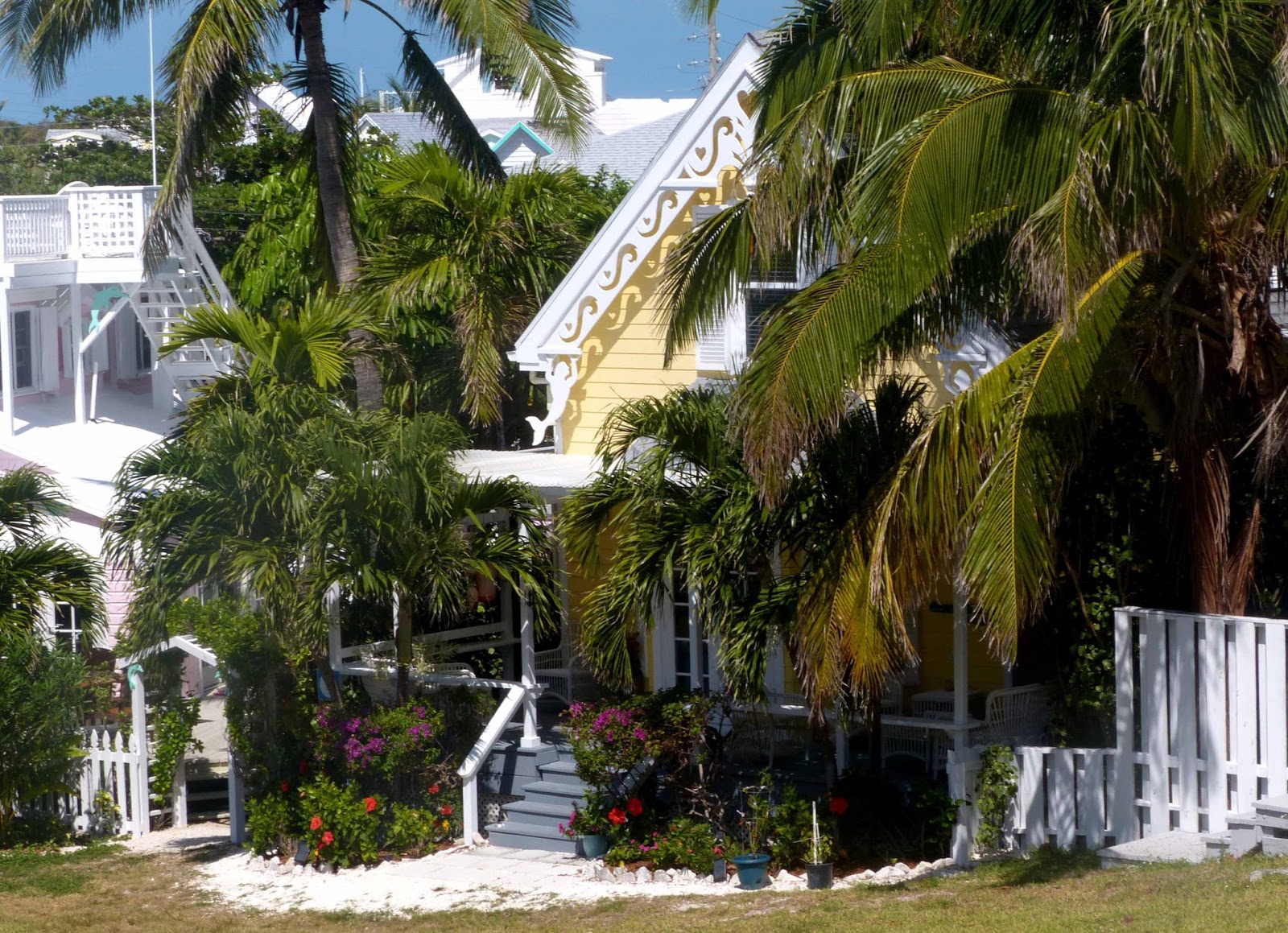 |
| Tidy Hope Town exudes charm and character. |
We stop at favorite restaurants and watering holes including a dinghy
ride to the south end of Elbow Cay for beach combing at Tahiti Beach and lunch
at Cracker P’s. My bike tire has been replaced with an almost correctly sized
replacement so we cautiously bike along the paved streets of Elbow Cay. The correct tire will have to wait until we
return to the States.
One Saturday
while we are in Hope Town, an opportunity arises to take a water taxi over to
Man of War Cay for the Boat-builders’ Festival and dedication of a new memorial
to the trade that has made generations of Man of War residents famous. The festival is primarily for the locals, but
we are welcomed to join in. We tour
several boat building businesses and have an opportunity to talk with the
current builders.
 |
| Albery skiffs are seen everywhere in the Bahamas and Florida. They are know for the quality construction that takes place in this small facility. |
 |
| Wooden Abaco sloops are hand made down the road and are still used for training and recreation in the area. |
There is a ceremony at the new memorial complete with school
children singing a catchy tune about boatbuilding on Man of War that still
replays in my mind. There are speeches,
visiting dignitaries, and hymns sung as this is a very religious community. Historic
boats line the docks and are open for touring.
 |
| The William Thornton is an example of a traditional inter-island sailboat that was build at Man of War. A wood boat, it doesn't hold up well in the tropic waters and is undergoing a major restoration. It sailed in the Parade of Sail in New York City during the US bi-centennial celebrations. |
As we take the water taxi back
to Hope Town, we pass Abaco Rage on the way to her Hope Town mooring; she was
also built on Man of War.
We’ve been
studiously watching weather and see an opportunity to head back to the
States. We depart Hope Town on the high
tide, head over to Marsh Harbor several miles away to top off the fuel tanks,
and begin the long passage to the northwest.
The sometime dicey Whale Passage is smooth, and we glide past Green Turtle
Cay and then the small and rarely visited Cays further northwest. Our course takes us along the Little Bahama
Bank until we drop off the western edge into the deep waters of the Atlantic
and the Gulf Stream. We enter the Stream
in the middle of the night and shortly thereafter the wind switches to the
north, something that wasn’t predicted.
Wind against current in the Gulf Stream can be quite unpleasant as is
the case this time. We take a diagonal
to the northwest to get out of the stream as soon as possible rather than
riding the 3 – 4 knot current to the north. We regret not being able to take
advantage of the speed offered by the current, but seasickness isn’t much
fun.
Forty eight
hours later we arrive in St. Augustine to be greeted by our friends Ted and
Sally on Amici.
 |
| Well..this isn't Amici but it is the boat on the mooring next to us - The Spirit of south Carolina, visiting St. Augustine with a crew of Boy Scouts. |
We are beat but rally the forces to enjoy several days with our
friends.
 |
| A gate along one of the side streets in the historic district. |
 |
| A garden scene from a restored boutique hotel recently opened near our marina. If you look in the yard beyond the fountain you can barely see a green painted wrought iron bench that is identical to the one we had that originally belong to Burt's great-grandmother. |
Once they depart it is time to
catch up on business that has been sidelined during our stay in the Bahamas. I rent a car and drive to Green Cove Springs
to pick up a huge pile of mail. We make
an appointment to check in with Customs and Boarder Protection to iron out some
issues with our Small Vessel Reporting System documentation that was fouled up
in Key West. And best of all, we go to a real American supermarket and replenish
the stores aboard. We are still in St.
Augustine on Easter Sunday, so we attend services at the historic Memorial
Presbyterian Church, originally commission by Henry Flagler in memory of a
daughter who died. It is a beautiful service in a beautiful sanctuary, enhanced
by an amazing pipe organ.
 |
| One of the spires at Memorial Presbyterian. |
Winds and
storms have been harassing us all spring, but we finally see a weather window
for the overnight up to Charleston.
 |
| First light as the Bridge of Lions opens to allow us to leave St. Augustine. |
Once again, it starts out pleasant enough,
but well after dark the wind picks up and switches to just off our nose. So here we go, pounding into short period
waves and counting the hours until we can head into Charleston Harbor. We arrive
to find that our friends on Amici will be arriving in the harbor after over a
week of travel on the ICW. As painful as these passages have been, they do
allow us to miss large swaths of the ICW that would be particularly difficult
with a deep draft boat. We have a lovely
happy hour and dinner on Amici and wish them a safe journey as they head off
the next morning for more of the ICW.
During our
stay in Charleston, we begin working on maintenance and cleaning chores that
are planned each spring. Burt replaces a
malfunctioning bow light and mounts new tires and a seat post (which was stolen
from my bike in St. Augustine) while I empty all the cabinets and lockers in
the interior of the boat, inventory the contents, and clean them and all other
surfaces with vinegar to remove and prevent regrowth of mildew.

 |
| Despite the work we still find time to walk the alleyways in the old town. In the bottom picture, in the background under the boxwood arch, is another copy of our old garden wrought iron bench, this time painted white. |
We take one day
off for a bus tour to Middleton Plantation outside of Charleston. What a delightful surprise!
 |
| The green and entry way in front of the remains of the Manor House which is actually about one third the size of the original. The other two wings were burned during the Civil War. |
The grounds and buildings are beautiful and
full of historical significance.
 |
| Huge, century old live oaks shade a garden path. |
 |
| The formal lawns and plantings are all symmetrical and based on English styles of the times. The Ashley Rivers is in the distance. |
 |
| A more naturalized pond with the pump house in the distance and the rice field beyond. |
 |
| Another pond with the chapel for the slaves across the way. the basement of the chapel served as an ice house. |
 |
| Classical sculpture enhances the formal gardens. |
 |
| And yes, alligators make themselves home in the many decorative water features. |
We take informative tours of the manor museum,
the gardens, and the slave quarters. We learn about rice planting as it is the
season to put in the new crops. And we have a low country lunch at a restored
tavern. We are there for five hours and
still have not explored everything when the bus returns to pick us up. It is a
beautiful day and upon returning to Charleston, we head to a roof top bar for
happy hour overlooking the town and harbor.
 |
| The view over the Cooper River from the roof top bar. |
After a week
in Charleston, we have another window to head offshore to Beaufort, North
Carolina. For once, the forecast holds
true, and we have a pleasant passage, arriving early in Beaufort to our
reserved spot at the Town Docks.
Finally, we have fresh water, and we give Exuberant a well-deserved
bath, washing months of accumulated salt from her deck and now rusty
stainless. Come late afternoon we stroll
down the cute main street and dine at a waterfront café, staying inside as it
is a bit cool for our tastes.
And now we
begin our trek up the ICW. We have 200
miles to go to reach the Chesapeake, and these 200 miles will be our only time
on the ICW since November. We are not
used to the constant chatter on the vhf and the wakes from a few of the larger
motor boats that don’t pass with courtesy. We make our way to Ocracoke Island
where we dodge a huge ferry boat and a dredge in the narrow and shallow
channel. We tie up at the inexpensive National Park Docks, accompanied only by
the ferries and dredge when they moor for the night.
 |
| Marsh grass at the entrance channel to Ocracoke and the harbor in Silver Lake. |
It is definitely off season here, but this is
a good place to hide from an upcoming gale and work on the boat. Burt polishes the exterior stainless while I
finish up the interior cleaning. We enjoy a few meals out at the local
restaurants that will be packed during high season. And, at the dock, we weather a serious gale
off Hatteras that results in a lost man-overboard, a capsized catamaran, and a
boat that requires a Coast Guard tow to safety.
We are protected by the high sides of the big boats moored around us,
but it sure doesn’t seem like the placid spring we were expecting.
With a break
in the weather, we rejoin the ICW, anchoring at the north end of the Alligator
Pungo Canal
 |
| We share our anchorage in the isolated Alligator River with just one other boat. |
 |
| A typical scene along the waterway in North Carolina - it is rare to find cell phone service. |
and enjoying a lovely sail across Albemarle Sound. We have dock reservations at Coinjock, an out
in the middle of nowhere marina that is famous for its prime rib dinners. We indulge in dinner and appreciate the safe
dock when the next gale blows through that night bringing one gust we measure
at 48 knots. We plan to depart the next
day but the strong winds have pushed the water from the Pamlico and Albemarle
Sounds into this portion of the ICW which terminates with a tidal control lock
further north. Our excess water has nowhere
to go but up, effectively closing the ICW as the low swing bridges are
underwater and the 65 foot bridges are several feet shorter, not a good thing
when you have a high mast and measure clearances in inches. So, here we stay in Coinjock which a friend
describes as 15 miles away from the middle of nowhere. Four days later, the water has receded with a
more northerly breeze and the Army Corp of Engineers has inspected the swing
bridges. We are good to go along with
the other 40 – 50 boats that have congregated here. It is a mad house, and we wisely decide to
stay at the end of the pack, listening to the many boats ahead negotiate
passing situations. Still, it gets
interesting when a south bound large barge and tug reach a tight turn in the
waterway just before a bridge We hear
the tug announce his approach and are able to get out of the way, but a
catamaran behind us is apparently not paying attention and meets the barge just
as it is approaching the bridge. The cat continues through the bridge while the
tug goes into full reverse to avoid hitting him or the bridge. Let’s say, the radio conversation is pretttty
interesting.
A stop at
Great Bridge allows us to replenish provisions (as nothing is available in the
middle of nowhere), and we head past the naval yards in Norfolk to Hampton,
Virginia. We plan to stay a few days
until conditions are good for heading up the Chesapeake, but with so many of
our plans this spring, we stay longer than expected. Rain and cold weather make a dock with
electricity, and thus heat, very appealing.
The day before the cold sets in, we bike out to Fort Monroe which
overlooks Hampton Roads, the confluence of the Chesapeake, James River,
Elizabeth River, and inlet from the Atlantic.
 |
| A small portion of the moat and walls at fort Monroe. |
Fort Monroe is the largest fort
ever build in the United States and was in service until 2011 when it reverted
to the National Park Service. There have been iterations of the fort at this
location since the days of the Jamestown settlement. Robert E. Lee and Edgar
Allen Poe were stationed here; Jefferson Davis was imprisoned here. The Battle
of the Ironclads took place just off the ramparts, and the fort became a refuge
for runaway slaves who were forced to serve the Confederate Army. In later
years the fort served as a training facility for the Coast Artillery Corp when
many lovely homes were built on the premises for the officers stationed
there. In its new life, these home and
the barracks are rental properties
 |
| A waterfront park and example of officer housings at Fort Monroe. |
and the old officers’ club is a fun beachside
restaurant where we enjoy lunch.
Looking
forward, once the wind veers from the north and the temperatures rise above the
50’s, we will take two days to reach our next destination, Annapolis. It is
mid-May, and we’re currently at 37 degrees latitude although at times it feels
like 37 degrees Fahrenheit.