Tuesday, March 7, 2017

Exploring Further in the Exumas


Before continuing with our exploration of the Exumas, I want to include a photo that I just found of the Shark Creek (Berry Islands) expedition that was mentioned in the previous blog. 
Shark Creek transits from the banks to the ocean side of Great Harbor Island

This creek is passable only at high tide and is so narrow that a dinghies can only travel in a single file. In this section there were large rays on the bottom which spanned the entire width of the creek.  So…back to the blog.

We head back north from Little Farmer’s Cay to Blackpoint Settlement 
The anchorage at Blackpoint Settlement

in the hope of finding some fresh produce, but alas, the freighter has taken everything to Farmers and the tiny store’s shelves are bare.  Burt gets in a good hike along the ocean side shore 
Waves along the eastern side of the island with a blow hole, by the people in the left side, spouting in fine form.

and of course, there is always another happy hour at Scorpios 
Burt enjoying a rum punch with John (from Canada) and Garth (from South Africa). The cruising community is quite international.  Behind them and across the street is the All Age School for Blackpoint.

and the dubious climb from the dock down to the dinghies in the dark, thanks to the cheap and strong rum punches.  You would think we would begin to learn our lesson.

It’s an eight mile hop north to Big Majors Spot (home of the infamous swimming pigs) and Staniel Cay.  After a great snorkel at Thunderbolt Grotto where fish and colorful corals and sponges abound, we head into the settlement looking for produce and dinghy gas.  In typical Bahamian fashion neither are available, but we do have a delightful late lunch overlooking the docks at the Staniel Cay Yacht Club (really a resort and marina).

We have a strong front predicted in 36 hours so we go further north to Cambridge Cay and its sheltered mooring field. Cambridge is part of the Land and Sea Park and provides excellent protection from winds of any direction.  Apparently, others have heard the same forecast as there are only a few mooring still available. Before the strong winds arrive we take a several mile dinghy ride to Rocky Dundas, two small barren islands that sport caves with stalagmites and stalactites. We snorkel the bigger cave and the surrounding reef, stop at two more interesting snorkel spots, and then head into the mooring field before the front arrives. And arrive it does with high winds and dark gray skies as we bob happily on our secure mooring. The winds keep up for several days, but we are entertained by explorations within this archipelago of small cays.  We walk and snorkel Honeymoon Beach, 
Honeymoon Beach where you rarely see any other people.  To the far left is a large stand of Elk horn coral for snorkeling.

hike along the cliffs above the oceanside beaches, 
An over view of Cambridge from our hike.  The ocean and Bell Rock are to the left; the mooring field is to the right.
Another view of Bell Rock. The name Bell is shared with nearby Bell Island, home of the Aga Khan. On a calmer day we snorkeled around Bell Rock.

snorkel at the aquarium, walk the nearby sand bores, and snorkel on a tiny cay that forms one side of the mooring field. We have a congenial collection of boats so there is a happy hour on a beach (until the mosquitoes chase us away) and a sunset dinghy drift where our friends see their first green flash.

Once the sea state in Exuma Sound is down to a manageable size, we leave Cambridge and head south to the next major collection of cays, otherwise known as the Pipe Creek area. Some boats take shelter in the protection of the cays, but with our draft, we anchor on the western side and explore by dinghy.  Our friends on Temerity stay in Cambridge as they are volunteering to be mooring field hosts.  On a calm day, they bring their dinghy down for some fun at Compass Cay. Here we are required to pay a small landing fee to enjoy this private island and marina.  The prime attraction is the school of tame nurse sharks.  At high tide the sharks swim up on a slightly submerged dock to be petted and fed. Our friends on Temerity, who had not seen this before, start out quite skeptical with Laura verging on hysteria, but end up in with the sharks just like everyone else.   
The marina owner chums the water with a fish head, causing the sharks to gather on the dock.
 
Burt and I give the sharks a little love.
You see, nurse sharks have very small teeth, somewhat like human baby teeth, and eat via suction rather than biting.  The marina manager says that the sharks can actually suck a lobster or a conch out of its shell. After playing with the sharks, we walk across the island to another aptly named Honeymoon Beach on the ocean side. We enjoy a picnic lunch and swim with the beach virtually to ourselves. 
The beach at Compass Cay, protected from waves by a barrier of reefs.

Chris and Laura have a few more hours before they need to return to Cambridge, so we take them on a dinghy tour of Pipe Creek, past private islands and beautiful second homes/estates. 
Boats anchored in Pipe Creek with one of the private islands in the background.

The inviting low tide sand bores make a stroll a necessity 
An irresistible sand bore where I found shells and sand dollars the day before.

before they head back to Cambridge at slack current. 

On a windless day we head 15 miles north to Warderick Wells and the headquarters of the Land and Sea Park. 
The mooring field at Warderick Wells.  The darker water is deep enough to accommodate boats; the light water is shallow sand.

The water is so glassy that we can see individual blades of grass and starfish in 20 feet of turquoise water. We snag a mooring in the north field and head off to do a little snorkeling.  While there is no wind, the currents through here are infamous, so one snorkels only at slack tide. Another front comes through while we are here with blackening skies and strong winds,
Stormy skies bring torrential but brief rain.

but again we are in a comfortable, protected spot. Hiking is a mainstay at Warderick Wells, so we take a long hike that starts along the ocean cliffs, 

Reefs litter the ocean side shore before dropping off into very deep water.

Enjoying (so far) this scenic hike.

winds its way through the interior, and ends on the banks side. 
Towards the end of the hike we must negotiate the Causeway, a bridge and length of piled rocks that traverse the water in the center of the picture.  This day we have strong west winds and the Causeway is awash at high tide making for a tricky passage.  The park headquarters is in the top right corner.

Friends that night refer to the hike as the Bataan Death March. With twenty boats in the mooring field, this is another sociable place.  We spend one particularly interesting evening on a friend’s boat. Among the guests are the assistant warden of the park and the administrative assistant, both Bahamians.  They share their knowledge of the park and its flora and fauna.  It is not always easy to socialize with the locals, so this is a special evening for us.

With more settled weather, we return to Staniel Cay. Yes, there is gas available for the dinghy, but we arrive several days after the provisioning freighter and, again, fresh produce is hard to come by. It’s time to begin thinking about moving to GeorgeTown and civilization. We make our way on the Exuma Banks to Musha Cay, the home of magician David Cooperfield. The anchorage is just off his picturesque beach where you can rent the “cottages and facilities” for $35,000 and up per night with off shore fishing and excursions to nearby islands an additional charge.  We pay nothing for the view and sunset.  
All this for a mere $35,000 per night!

We stay two nights, spending the intervening day exploring with our friends by dinghy as the water is too shallow for the mothership’s draft.  We weave between islands and sand bars and stop to snorkel at Rudder Cay where David Cooperfield has placed a piano and mermaid sculpture in about 15 feet of water. 

The next morning we head out into Exuma Sound for a wonderful six hour beam reach down to GeorgeTown and Elizabeth Harbor. GeorgeTown elicits both love and hate.  With 300 boats in the harbor, it is crowded and the vhf chatter goes constantly all day.  But, we have access to our first decent grocery store in five weeks, a laundromat, a hardware store, a great hairdresser, and a multitude of restaurants and resorts. There are actually streets with traffic although none with stop lights. We settle in for an extended stay.  Burt is helping out with the race committee for the annual regatta.  We spend afternoons at Chat and Chill, a beach bar on Stocking Island where volleyball, Mexican Train Dominoes, and basket making are the mainstays. I spend an afternoon snorkeling with my friend Gayle who is a marine biologist and return far more familiar with the corals, sponges, and worms we observe. By the way, Gayle and Bill’s boat is named after a marine worm she discovered.

The frenzy in the harbor peaks during the week of regatta.  There are competitions of all kinds: kayak racing, volleyball tournaments, beach golf, a poker run in dinghies, sand castle building – the list goes on.  This place is accurately described as “Daycare for Adults”. Burt participates in the volleyball and bocce tournaments, and Exuberant sails in the big boat Around the Island Race, an all day, 30 mile affair transiting the harbor and around the ocean side of Stocking Island. We come in third in the large mono-hull class – nothing stellar but a good showing as our competition is racing in stripped down boats, while we are competing in our heavily laden, full time live-aboard home. Our crew of seven includes two couples who had never before participated in a race – they had a blast for their first time experience.

Our gallant race crew accepting the third place flag - Miles from m/v Ariel, Chris and Laura from s/v Temerity, Jim and Chris from s/v Radio Waves, and ourselves.
We were too busy to take pictures during the race, but here is a shot of a Bahamian sloop that participated in the In Harbor Race.


The last few days of regatta are compressed into one day as a huge weather system is about to descend. For the past four days we have had torrential rain squalls and winds 25 – 30 knots with gusts to the low forties. When the first gusts hit, a number of boats drag anchor resulting in panicked cries over the vhf.   
The initial squall line brought wind gusts to 40 knots and torrential rains that obliterated the nearby boats.

We are tucked in very close to the windward shore with the boats around us well secured and widely spaced, so we get some sleep at night.  
Four days later it is still blowing stink but our anchorage several hundred yards off Lumina Point Resort provides relatively calm water and a beautiful view.

Everyone is stuck on their boats and cabin fever is the norm.  Once things settle down in a day or two we will leave GeorgeTown for further exploration, the destination dependent, of course, on the coming weather forecast. That’s just how it is. 

Our time in the Exumas has been delightful, but as with everything in the Bahamas there is a trade off. We snorkel and hike in spectacular places, meet new friends and connect with old ones, and sail through breath-taking waters.  We also struggle to get internet, to find fresh produce, and to adjust to the inefficiencies of island time.  I end this blog with a picture from Blackpoint which illustrates the contrast between the first and third world aspects of the Bahamas.  
A novel approach to stringing utility wires - and now we know why sometimes things just don't work.

Tuesday, February 7, 2017

Bahamas Bound 2017


Every year cruisers struggle to find a weather window to cross into the Bahamas, but this year is a bit different.  Rumor is that La Nina is changing the weather patterns, and just as we are finally ready to leave Marathon, the perfect window opens.  We will spend considerable time in the Gulf Stream so we are happy to go on what is considered “Trawler Weather”, in other words, very light wind and motoring conditions.  We leave Marathon as soon as it is light to avoid any lobster buoys and make a beeline to the deep water outside of the barrier reef, looking for a push from the Gulf Stream.  We find very little current but also find smooth seas that make for pleasant conditions in the Stream.  It seems like all of Florida is leaving with us, but we see very few other boats. We enjoy dinner at sunset while in the Stream
Sunset as we have dinner in the cockpit - the Gulf Stream isn't always terrifying.

and marvel at sunrise on the Bahama Banks with utterly glassy water.  
A dramatic sunrise the next morning on the Great Bahama Banks.

Twenty seven hours later, we arrive at Great Harbor Cay in the Berry Island chain to the welcoming waves of Chris and Laura on Temerity who crossed over from Miami but arrived prior to daylight.
Temerity greeting us as we arrive in the Berry Island - great to see them after several months.

Our two boats make way into the completely protected harbor of Great Harbor Cay Marina. Shortly after tying up at the docks we are cleared through Customs and Immigration by very friendly officers.  We will stay here for about a week as a strong cold front is predicted to pass through. 

This is our first visit to the Berry Islands, and we are looking forward to doing a lot of exploration. Great Harbor Cay has an interesting history.  Back in the 60’s it was privately owned and developed as a high end resort.  The likes of Jack Nicholas and numerous Hollywood stars had homes along the 18 hole golf course. There was an architecturally unique hotel and several high end restaurants. After a series of bankruptcies and the curtailment of the Bahamian drug trade, all that remains now is the marina, a beach bar, and an overgrown 9 hole golf course.  In more recent years, parcels of land have been sold along the beach, and lovely second homes are tucked into the tree-lined shore.

Our first adventure takes us to Shark Creek, a mangrove creek that bisects the island.  Temerity joins us as we take our dinghies through the creek at high tide.  In places the prop stirs up the bottom, and the mangroves arch over our heads obliterating the sky.  It is something out of “The African Queen”. Beneath us large rays lay on the bottom with their wings stretching from bank to bank. Eventually the creek widens out into a tidal lagoon where turtles dart about in our wake.  We are so busy navigating the shallow waters and overhanging branches that we never take a picture. The lagoon empties into Sugar Beach which encompasses the entire eastern shore of the Cay.  We have just enough time to investigate one outlying cay before the falling tide beckons us to dinghy back through the creek to the marina.

Great Harbor Cay is a wonderful place to do some biking. The roads are well maintained by Bahamian standards and have virtually no traffic.  Every car that passes gives you a vigorous wave – it’s just a friendly sort of place.  The marina has free loaner bikes which is a good thing as I blow out a tire on our first trip. The next day, with the replacement bike, we ride the entire length of the island, something over seven miles each way.  No one told us about the hills, but we enjoy the many vistas
Yes, the Bahamas have hills - the ocean is to the left, interior ponds on the right.

and stop at all the beach access points along the way.  Typically, the windward beaches are untenable during the winter easterlies, but we are having a rare period of westerly wind so I manage a wade or swim at each of the beaches.  
A refreshing dip at Lover's Beach

The northern beaches are tucked in between rocky outcroppings, 
Cave beach

while at the south end there is endless sand and fun exploration at low tide. 
South end of Sugar Beach

Meanwhile, a beach bar on this east facing beach, with easy access from the marina, becomes our regular hang out. And if we get bored in the evenings, the marina sponsors events such as a deep sea fishing contest, a potluck, and a barbecue night. 
Weigh-in at the fishing tournament.

The west winds are still with us but they are abating.  We leave our protected home in the marina and explore the eastern shore of the Berries with the mother-ship. Our first night is spent anchored just off our friendly beach bar.  
The view from the beach bar - our chairs and umbrella are set up in the sand.

We spend the day on the dinghy exploring the outlying small cays.  It is rare to ever see another set of foot prints.  
At low tide the sand bores dry out. Our beach combing cay is in the background.
A random starfish in the shallows.

We pull the dinghy up on one of these cays and start walking the sugar sand beach that faces east. 
The dinghy at anchor while we go off exploring.

The east facing shore of the cay

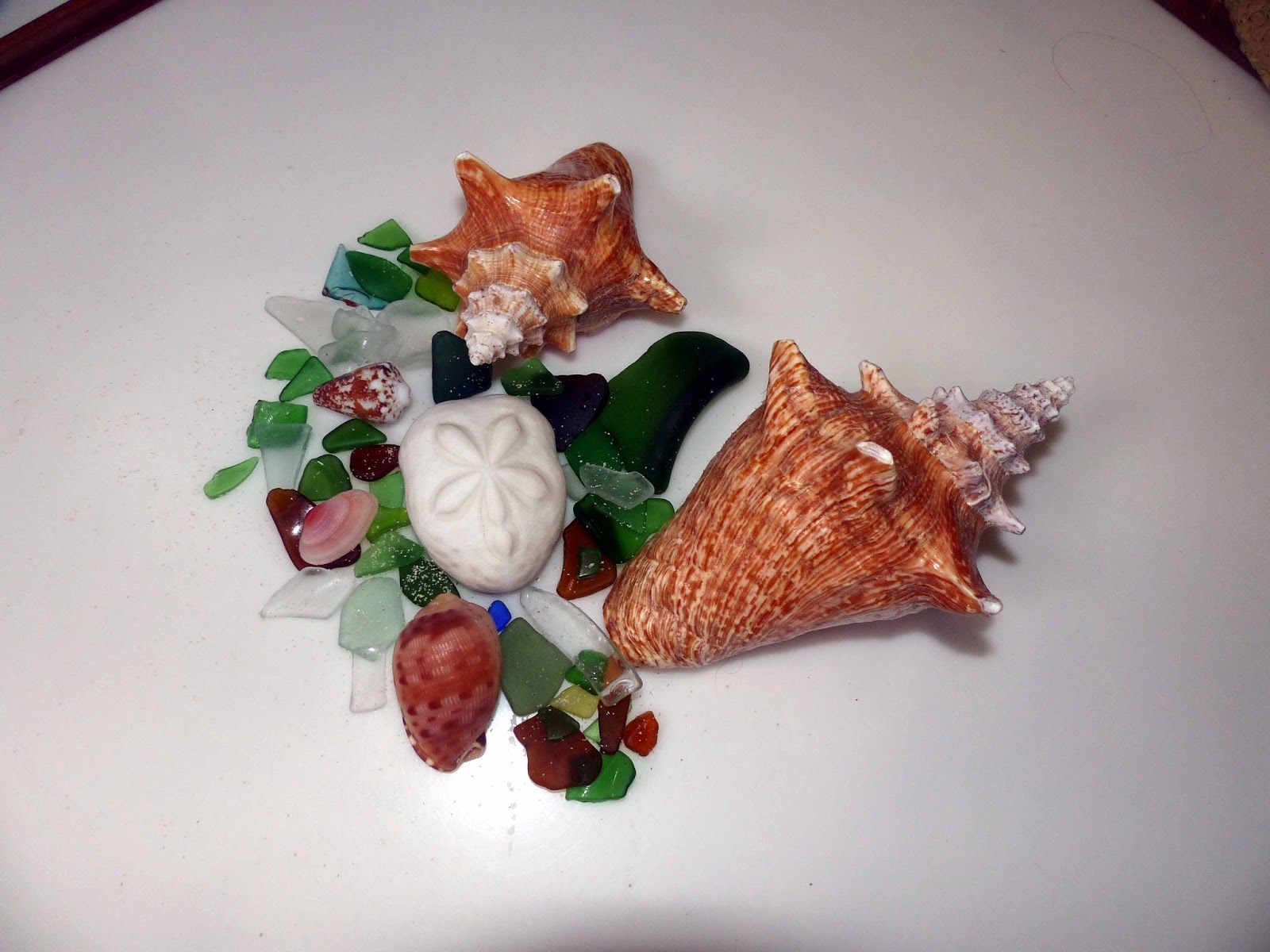
We soon discover it is the mother-lode of shells and beach glass.  Live conchs are tucked into coves amongst the sea grass 
Live conchs in the crystal clear water.  The ones we collected were dead and up higher on the beach.

and empty shells litter the water’s edge. It is not long before we become very selective about which shells and which pieces of sea glass are worthy of our collecting.  
Conchs, a sea biscuit, several unique shells, and lots of good sea glass - one day's haul.

This is by far the best spot we have found for beach combing in the Bahamas, and if it wasn’t for the westerly winds, we could never have accessed this cay.


The next day we sail a few miles down the chain to an anchorage known as Devils/Hoffman.  Most of the anchorages in the Berries are for shallow draft boats, but this spot has sufficient depth for our boat.  The surrounding cays are all uninhabited, but we are joined by a number of other cruising boats.  Temerity knows of a Blue Hole on a nearby cay so we dinghy over to a beach and hike up a trail to discover a remarkable blue hole tucked into the rugged landscape. The water is crystal clear, but as Chris discovers when he jumps in for a swim, it is still salt water which feeds into the hole through underground streams.
The Blue Hole from above.

And a water level view from a cave formed at its rim.


Later in the afternoon, other cruisers suggest that we go snorkeling on the east side of another cay.  We land the dinghies on a protected beach and proceed to swim between two cays to the oceanside reef.  At one point it is so shallow that we ride small waves on our stomachs over the rocks and chunks of dead coral that litter the passage. The outer reef is full of sea fans and a few stands of elkhorn coral. Small, colorful reef fish swim along with us, but the high point is an encounter with two beautiful spotted eagle rays.  It is a magical day, and we enjoy a majestic sunset in this isolated anchorage.
A view west towards the sunset with our friends' boat Gratitude in silhouette.


The next day we head thirty miles southeast to Nassau.  
A row of huge cruise ships signals the entrance to Nassau.

We will take a marina slip while another front passes through.  Our stop also gives us an opportunity to grocery shop at a Fresh Market, the last full service grocery we will see for several months, and have a fun dinner out at a nearby Chinese restaurant.  The winds are still up when we leave the marina, so we tuck into nearby Rose Island and anchor in its lee for the night before heading into the Exumas. 

This is the second year in the Bahamas for our friends on Temerity, but last year they skipped some of the stops in the northern Exumas, so we aim to show them some new and special places.  We have a glorious beam reach from Rose Island to Shroud Cay, the northern most cay in Exuma National Park.  Shroud is not a single island but rather numerous small cays linked to one another by mangrove creeks.  We arrive late enough in the day to only have time for an exploration of a nearby sand beach that uncovers at low tide.  Here, the only footprints are our own, and we find a treasure trove of sea critters including star fish, sand dollars, and a plethora of conch.  
 
Our location for a late afternoon exploration of the sand bar off Shroud Cay.

Live conch nestled in to a small cove

Star fish are everywhere.

A live sand dollaar.

Since this is a national park, it is also a no take zone, so everything both live and dead are to not to be collected.  But, the pictures tell the story. 

The next morning at close to high tide we leave with Temerity and also the crew of Providence to explore the only creek accessible to motorized dinghies.  It’s a long haul from the anchorage and part way there our outboard engine starts to falter.  Thank goodness we are in the company of two rescuers.  Our dinghy is hauled to a nearby beach, and we split up into the two functional dinghies.  Wandering into the interior of the cay via a wide creek, 
A mangrove creek like the one that takes us through the interior of Shroud Cay.

we emerge on the ocean side at a place called Camp Driftwood.  For many years a hermit lived here atop a hill in a hut constructed of found materials.  After he left, the DEA took over the location for an observation post that overlooked the drug dealers on nearby Normans Island.  Today, it is a wonderful perch to observe the beauty of the surrounding area.  
The view from Camp Driftwood out over the ocean.

And looking back towards the maze of mangrove creeks.

Once again, before the tide drops too far, we head back to our boats and during the following rainstorm, Burt cleans the carburetor of our recalcitrant outboard. 

Soon we are back in business to make the short hop down to Hawksbill Cay, another cay in the park. Hardly anyone stops at Hawksbill, and that’s a shame.  Beautiful pocket beaches separated by rocky outcroppings dot the western shore.  At the north end, large sand bores uncover at low tide.  

We lead Temerity up there to explore and attempt to leave our dinghies in places where the water won’t dry out.  We take a long walk along the sand bores with nary another soul in sight.  
The spectacular sand bores on the north end of Hawksbill Cay.

Upon returning to the dinghies, we realize this is a trip best taken on a rising tide.  We push the dinghies into shallow water, but it is so shallow we need to pull the dinghies a VERY long way to arrive in sufficiently deep water to run with the engine.  We arrive back at the anchorage just before sunset. 
Sunset at Hawksbill Cay as a mega-yacht passes in the distance.


The weather here has been unsettled.  A trough (an elongated weak low pressure area) is lingering over the central Exumas.  At times it moves a bit north; at times a bit south.  The result is generally lively wind and rain showers alternating with clearing skies.  We have a brisk sail down to the settlement of Blackpoint where we spend a night.  Burt gets a haircut on a bench at the laundromat overlooking azure waters, and we indulge in happy hour at Scorpio’s Bar with many other cruisers.  With two for one rum punches, you always end up having two which isn’t necessarily a good idea when you have to negotiate a steep ladder down to the dinghy with an occasional shark swimming by.  Despite the indulgence, all survived intact.

Another short hop south is Little Farmer’s Cay, our destination for the weekend to observe the 5 F’s (First Friday in February Farmer’s Cay Festival), a favorite with the cruising community.  This is a combination of a traditional Bahamian sailing sloop regatta and an island homecoming in this settlement of 80 (but now much higher) people.   Race boats from Nassau and a large group of ex-Farmers residents arrive on a freighter Friday morning.  Others arrive by aircraft and power boats from surrounding settlements. 
Cruisers and locals all stake out a claim on the beach at Ty's Sunset Bar, right in front of the finish line. In the distance on the right, you can see one of the private aircraft parked by the runway, bringing spectators and dignitaries from all over the Bahamas for this event.

This year 18 Class C sloops will be racing, the largest number we have ever witnessed. Friday afternoon they hold a long distance races in very light air.  The boats are towed north and out of our sight, only to reappear hours later for a finish right in front of the beach bar. 
 
Glassy conditions for the distance race finish.
Loud music and hearty cheering keep us entertained.  
A dramatic sunset the first night at Farmers Cay foretells the change in weather the following day.

The next day three around the buoy races are scheduled, and the wind has definitely picked up.  The sloops carry three sets of sails and start the day with the medium sized sails but end up flying the small sails before the races are completed.  The race start begins with the boats all anchored along the starting line.  At the signal, the anchors are hauled (by hand) while simultaneously the sails are hoisted.  Chaos is the best word to describe the situation, but it is not long until they are all speeding on their way with bodies splayed on the hiking boards. 
The start horn sounds and crews begin haul up anchors and sails.

The boats begin to power up.
 
And they are off!

The wind picks us and one boat capsizes. They have no flotation so they are hauled back to the beach and bailed in the shallow water.  Of the 18 boats that races, four either capsized or had a break down. 

Again, the finish line is in front of the bar where crowds of onlookers cheer on their favorites. 

The crews put on a good show as they pass through the finish line.

Storm cells come and go during the day, and at one point all the small aircraft parked on the runway behind the beach bar take off in a hurry – there are no tie downs here if the storms decide to pull a big punch.  As the weather deteriorates, we head back to the boat at dusk and miss the trophy presentation.  The next morning we sail back to Blackpoint where we hear the good news that Smashy, the local boat, has won second place.  Several years ago, Burt helped launch Smashy after it was rebuilt by the boat-builder/owner.  We’re always pleased when the local boys do well.