Monday, September 24, 2012

Working Our Way Further South


We are sitting in Newport, still twiddling our thumbs, and waiting for a weather window to make the long dash to the Chesapeake.  The tropical storms and hurricanes keep coming and one, Leslie, just seems to be dawdling and wandering around the Atlantic.  She is of no danger to us in a harbor, but out in the ocean there are sizable swells that would make for an uncomfortable voyage, to say nothing of the fear she might take another unexpected change of direction and head towards us.  So, impatience finally gets the best of us, and we decide to take a more protected route down Long Island Sound. Here you are controlled by the timing of currents.  The first obstacle is the Race, formed by the narrow passage joining Block Island Sound and Long Island Sound where the water depths change dramatically.  We zip through at greater than hull speeds and spend a calm night anchored along the north east shore of Long Island.

The next morning we get an early start as we want to arrive in the protected harbor of Port Jefferson, Long Island before a strong cold front passes through with winds predicted to reach 60 knots.  We cover the forty miles on a fast beam reach, pull into the harbor, and anchor in the protection of a high bluff. As the wind continues to build, the harbor fills with other boats seeking its protection.  When the front finally passes through we see over 30 knots for a brief period of time, but we know that out in the Sound things are much worse and not far away, at Coney Island, a tornado has been spotted.  Port Jefferson looks like an interesting town with a mix of very expensive homes along side regular neighborhoods.  The harbor entrance is formed by sand dunes and stretches of beach.  We would love to explore, but the weather keeps us on our boat. 

Our final destination on Long Island is Port Washington, just a stones throw from La Guardia airport. 
House near Kings Point outside of Port Washington - notice view towards NYC

 Another well protected harbor, it caters to cruisers – even the grocery store has a dinghy dock.  Here we provision for the trip to the Chesapeake and socialize with other cruisers who are awaiting a weather window to head south – we are definitely part of the fall migration now.  Leslie finally heads off to Newfoundland, and the winds and seas moderate so we can begin our passage.

The morning of September 11, 2012 dawns with crystal clear blue skies.  We leave Port Washington early to make the beginning ebb (favorable) current through Hell’s Gate, the passage where Long Island Sound merges into the East River. 
Coming into Hell's Gate - notice the disturbed water

Although we are just past slack, the current is strong enough to make the boat feel squirrelly underfoot.  We are flying past Manhattan at over 11 knots when we realize it is just after 9 am on a day so similar to one eleven years ago. It is a very disquieting experience.  The Empire State Building and the Chrysler Building sparkle in the strong sunlight.  
The Chrysler Building on a beautiful NYC morning
The UN buildings from the East River


 Then, between several other buildings, we glimpse the new One World Trade Center tower.   
One World Trade Center rising from the ashes of the original World Trade Center

It has reached its full height, but we understand it is still several years from completion.  If we had been in this same position eleven years ago we would have witnessed jets impacting similar towers. Those painful visuals haunt us, and it is difficult to gaze off in any other direction until we begin to leave Manhattan behind us.  Now it’s time to dodge the fast Staten Island Ferries that are accompanied by two security boats each. Otherwise, the commercial traffic is fairly light as we pass by the Statue of Liberty and head out into the Atlantic. 
The Statue of Liberty waves good-bye as we leave NYC harbor


We have 140 nm of open water sailing, or should we say motoring.  The strong winds and big swells are gone, and we stay about three miles off the New Jersey coast.  We are making good time and realize we should round Cape May at dawn with a favorable current going up Delaware Bay, so the decision is made to make the entire trip to the Chesapeake in one hop.  We are in communication with one boat about an hour ahead of us, and he is riding the currents the entire way.  But, being just one hour behind results in an unfavorable current for us come mid-afternoon, and we slog up the last reaches of the bay and through the Delaware and Chesapeake Canal, pulling into an anchorage just west of the canal about three hours behind our friends – that is what an adverse current can do to you. After 224 nm and 35 hours underway, we are happy to be in the Chesapeake, away from any brewing Atlantic storms and safely anchored in the Bohemia River for a well deserved night’s sleep.

The next morning we head into Harve D’Grace, a short distance away, and take a dock to do some serious cleaning as we haven’t been at a dock or had access to a fresh water boat wash since mid-June.  The hull and deck are caked with salt, and the canvas bimini and dodger have a serious case of mildew.  It’s a long day of scrubbing, and we collapse into bed after a delicious dinner cooked for us by the boat docked next to us.  Our neighbor, a full time livaboard, must have seen our state of exhaustion and kindly brought over a gourmet meal – another example of how thoughtful the cruising community can be.  We are most grateful. Grateful, that is, until we wake up the next morning to find we have been infested with bugs of Biblical proportions that have stained the deck and canvas.  Two more hours of scrubbing later…

So, it’s a quick hop down to Annapolis where we secure a mooring buoy in front of the Naval Academy and await the arrival of Burt’s brother and sister-in-law. Our guests tour the Naval Academy while I borrow their car to do some serious grocery shopping. Then, it is off to St. Michael’s, an historic town on the Eastern Shore.  We were here years ago by car, but now enjoy the approach by water.  It is Sunday afternoon, and the stream of boats leaving this popular destination makes the plotted course on our GPS quite unnecessary.  We have just missed the final “log canoe” sailing race of the weekend, but one of the boats is viewable onshore.  These narrow, traditional sailing craft built out of well hewn logs are similar to the Bahamian sloops – they employ a sizable crew, on boards that extend far beyond the gunnels, to counter balance the tall rig and huge sail plan, resulting in boats that can really scoot in a breeze. 
One of the log canoes packed up after a weekend of racing

We explore the Chesapeake Bay Maritime Museum which houses an extensive collection of traditional boats, a boat restoration facility, and a myriad of exhibits describing the history and industries of the Chesapeake. 
This restored lighthouse is the centerpiece of the museum

No trip to the Eastern shore is complete with out sampling some crab, and we enjoy a late afternoon snack overlooking the picturesque harbor.  The next morning we take time to walk the side streets of St. Michael’s, enjoying the many attractive restored homes and gardens, before setting sail for the Severn River, near Annapolis. 
Typical home along the streets of St. Michaels

The weather is taking a turn for the worse, so we anchor in a secluded creek off the Severn and enjoy a sunset accompanied by the sounds of ospreys and herons.  The next morning it is blowing stinkers, so we make our way back to mooring field in Annapolis to wait out the blow.  The combination of high winds from the southwest and an unusually high tide result in flooding and the closure of some streets and sidewalks, a phenomenon we have heard about but never witnessed in Annapolis. 
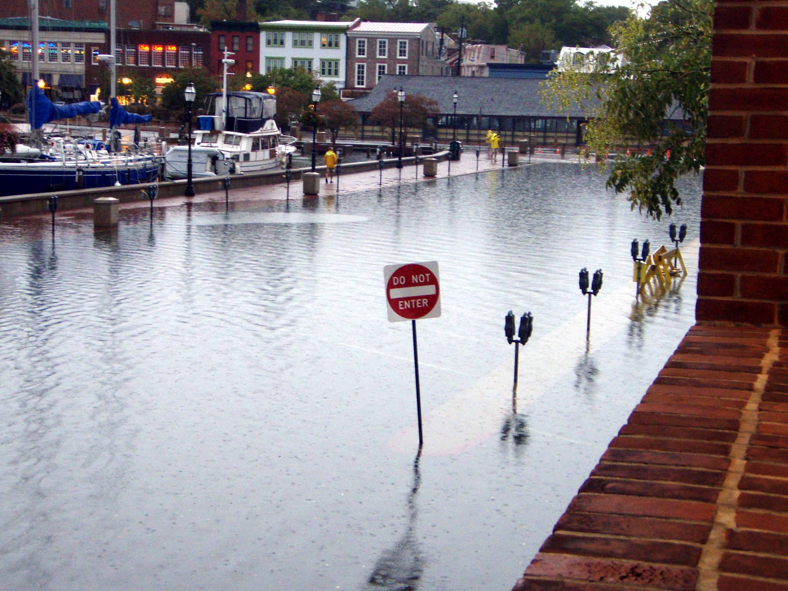
Flooding along the Annapolis waterfront


We are now back on our own again.  It’s time for errands and boat chores.  Burt is making improvements in the electric system in anticipation of adding solar panels in a couple of months and rebuilding a head. I’m doing laundry, bookkeeping, and scraping some peeling varnish. But it’s not all drudgery – cruising friends have pulled up to a ball near us, and we spend several evening visiting with them.  In the past year, our list of cruising friends has grown astronomically – we rejoice at the reunions but feel sadness as we eventually part ways.

And finally, it is a football Saturday here in Annapolis.  The Academy is playing VMI, and there are still tickets available.  So, we hop on our bikes and weave through all the traffic to the stadium where we score general admission tickets.  That gets you the right to sit on a sloping lawn in the end zone corners. These might not be the best seats in the house but they are cheap, roomy, and in the shade which is a pretty good deal on a hot, sunny afternoon.  We are used to Big Ten football with all its hoopla, but the military takes it one step further.  While the band may not be quite as big, neither Michigan nor Ohio State can order up two F-18’s to scream over the stadium right before kick-off.
Two dots in the sky are the jets - and they do make a lot of noise
The Midshipmen march into the stadium


There are plenty of other traditions on display and, best of all, the Midshipmen come out victorious. 

Shortly we will leave Annapolis to travel 15 nm south to the Rhode River and the site of this year’s Seven Seas Cruisers Annapolis Gam.  We have volunteered to help with the set up, and following the Gam, will return to Annapolis to attend the first few days of the annual boat show. After that it’s off to warmer waters.

Tuesday, September 4, 2012

Back to Civilization


It is a short hop through dense fog south to Boston.  The channel weaves through outlying islands and shoals.  Our fog horn is blaring, we are motoring at low speed, and our eyes are alternately glued to the radar and squinting through the fog to discern other boats. It is a bit intimidating.  At one point we see a large ferry boat lurking in the fog, not moving, and just outside the channel. On VHF Channel #16 we are hearing a pan-pan for a ferry that ran aground, but we understand them to be off Marblehead, quite a distance away.  Later we find out that the ferry we saw was the one that had run aground, just before we passed by.  Had the location of the ferry been correctly transmitted, we would have been the first rescue vessel on the scene.  On the way into Boston Harbor, Coast Guard vessels, fire boats, and other ferries are speeding past us, and happily all the passengers are safely transported back to Boston.  Later that day, after the tide rises, the humiliated ferry boat limps back to Boston.

Once we get to downtown Boston, the fog has lifted and it is a glorious, blue sky day.  We pick up a mooring ball right off downtown accompanied by our friends from Australia – we are almost in the shadows of the skyscrapers.   
Sunrise at Boston Harbor - our friends' boat is the white one

We have one and one-half days to see all of Boston so our friends are in for a stretch of “power tourism” American style.  We hit the ground running, well, actually walking on the Freedom Trail.  It weaves through the modern city to most of the interesting historical sights. We visit Faneuil Hall, the Old State House, and the Old South Meeting House, all places where the events of the revolution were hatched. John Adams, Benjamin Franklin, Sam Adams, John Hancock, and Paul Revere all walked these halls. The Boston Tea Party was planned at the Old South Meeting House, and the Boston Massacre occurred steps away from the Old State House. 
Old South Meeting House where the Boston Tea Party got its start

We wander through Boston Commons, a park, and on to the Beacon Hill neighborhood which is graced by many restored row houses.  
Gracious Beacon Hill town house
 
 
The next morning we take the dinghies through a lock which controls tides and into the Charles River. It is a five mile motor through placid waters past parks, boat houses and universities that line the shore.   
MIT's Boathouse on the Charles River

We pass MIT and Boston University on our way to Harvard. There is no dinghy dock available so the dinghies are locked to a railing along the shore, and we trample through a weedy area to reach the sidewalk.  With the mud and burrs brushed off, we regain our dignity, and walk onto the grounds of this bastion of higher education.  Harvard Yard is lush and shady and lined with lovely classical brick buildings. 
The Chapel at Harvard University

Although the students have not yet arrived for the fall semester, it is still a beehive of activity.  On the dinghy ride back, we are passed by sculls and pleasure boats – everyone is out enjoying this beautiful late summer day. 

After a quick lunch on the boat, we resume our trek on the Freedom Trail.  Our next destination is Paul Revere’s house, but we manage to get lost in the winding and confusing streets of Boston’s North End.  And the streets are packed.  This is the festival of St. Anthony and St. Lucia in the predominately Italian section of town.  We crowd on to the sidewalks as a parade like procession passes by in the street.  There is a band and a statue of one of the Saints held high and adorned with streamers and many dollars pinned to the statue’s robe and the streamers.  
Festival in Boston's North End

 The parade moves on although we hear the hub-bub long after it is out of sight. We finally find Paul Revere’s home, a well restored building squeezed in between other older homes and shops.  It gives us a sense of what life was like in 18th century Boston. 
Paul Revere's home

Just down the street is the Old North Church, home of those famous “one if by sea, two if by land” lanterns.  It, too, has been beautifully restored and is still in use as a church today.  
Old North Church


Our final destination takes us across the Charles River to the home of the Constitution, the oldest commissioned ship in the US Navy.   
The Constitution - too big to fit into the picture frame!

Yes, she is still manned by the Navy and just the week before, she hoisted sails for a short journey through Boston Harbor. Recently restored in anticipation of War of 1812 commemorative events, everything in the boat is historically correct and as original as possible.  The only modern additions are electric running lights and electric bilge pumps.   
And those electric bilge pumps? Built by Gorman-Rupp from our home town of Mansfield, Ohio

We go through extensive security to go aboard and are guided by naval personnel. 

We have worn out our Australian friends, but that’s OK as we are spending the next day sailing to Provincetown to await appropriate winds and currents to make the passage through the Cape Cod Canal.  Two days later with favorable winds and currents we have a glorious 85 nm sail to Bristol, Rhode Island in Narragansett Bay. At one point we hit 11 knots, far beyond our calculated hull speed. We have been in Bristol before, but not by boat. Besides its famous Herreshoff Museum which we visited a few years ago, Bristol has a lovely bike path that extends all the way to Providence and a number of attractive restored homes of wealthy sea captains. 
Captain's home in Bristol


We are twiddling our thumbs, first at Bristol and then back at Newport, as there is a threat of hurricanes in our stretch of the Atlantic. This gives us several days to do repairs, provision, do laundry, and enjoy our surroundings.  Bryan and Beth pay us a visit, and we take a scenic hike with them along a point of land east of Newport that is part of the National Park System. 
Beth, Bryan, and Burt hiking amongst the rocks at Sachuest Point

Our anchorage at the entrance to Newport Harbor is the perfect vantage point for viewing the many classic yachts entered in the annual Labor Day Classic Boat Regatta. There are over 50 boats participating in this International Event and at one point they all parade past our bow and through the anchorage area on the way to the reviewing/judging stands. 
The 12-meter American Eagle leading the boat parade with a bagpiper playing on the bow.

We need our sunglasses as the glare off the varnish work is so bright – one appreciates the willingness of others to maintain such beautiful yachts. Outside the harbor and under sail, we see everything from wooden twelve meters, to classic one designs, to ocean worthy large ketches, gaff rigged sloops, and schooners.
Herreshoff designed gaff rigged sloop

 Nearby the race course, restored motor yachts provide a viewing platform for their owners. 
Elegant restored motor launch


So now we wait. What sort of torrential rains will we receive from Issac?  How high will the ocean swells be that Kirk produces?  Where exactly will Leslie’s track be? And another tropical depression named Michael just popped up. Our trip south to the Delaware Bay entrance is about 240 nm of open ocean sailing, and we don’t want any surprises along the way. So…the thumbs keep twiddling.

Friday, August 24, 2012

Heading Up West (?)


If the inverse of “Down East”, the direction we have been traveling for almost a month, is “Up West”, that must be where we are headed.  We have a decent stretch of weather with winds not exclusively out of the southwest, so it seems prudent to begin the trip south.  Leaving Mount Desert is difficult as we have enjoyed it so much.  We feel a bit melancholy, and others with whom we are occasionally cruising say the same.  So, we take a small hop just four miles south to Little Cranberry Island.  This small island is one of only a handful of Maine islands that are inhabited year round.  Here there are few facilities for tourists, and the harbor is full of lobster boats.  
Waterfront at Little Cranberry Island

 Biking through the island, we find the mosquitoes out-number the residents exponentially; it is a true blood letting, and we beat a hasty retreat back to the boat despite the efforts of the proprietor of the local restaurant, armed with various bug sprays, who wants us to stay for dinner. We are safe from the little monsters on the boat and enjoy a beautiful view northwards towards Mt. Desert. 
Our final view of Mt. Desert Island


The next day we have a glorious sail through the Deer Island Thorofare, a rock strewn and relatively narrow passage between islands.   

Vistas along the Deer Island Thorofare


Upon entering Penobscot Bay we find ourselves sailing along with one of the classic Maine schooners that ply these waters. 
We're crossing tacks with this beauty

Our overnight is in Pulpit Harbor, a protected but crowded anchorage on the east side of North Haven Island. Just after dropping the anchor, a huge schooner arrives in the harbor and somehow shoe-horns herself in next to us. 
And our neighbor in Pulpit Harbor

We have one last evening happy hour with three other couples we have been with off and on; we are all heading in different directions now.  A layover day in Rockland gives us the opportunity to re-provision, do laundry, and pick up fuel for the trip south.

An early departure the next morning takes us out of Penobscot Bay along coast line we never saw when we came in in a dense fog.  Maine is certainly gorgeous when you can see it, although we are still cursing the numerous lobster pots. 
Lighthouse on a rocky isle along the Atlantic coast

Our next destination is Linekin Bay, the site of my earlier experiences in Maine.  Back in the late 1950’s my family vacationed at the Linekin Bay Camp, a rustic resort that focused on small boat sailing. This is where I had my first real experiences sailing, and I want to return to see if it is still as I had remembered.  The bay is much more developed, moose do not roam in the woods, and all the wooden boats have been replaced by fiberglass Rhodes 19’s, but otherwise it was quite the same and, happily, well maintained.  We enjoy a dinner at their deck restaurant overlooking the bay. 
Linekin Bay Camp


From Linekin Bay it is a short hop to Boothbay, but we do it via a detour to Squirrel Island which lies just outside the bay.  Squirrel Island is privately owned and the home of many large, well maintained “cottages” dating from the late 1800’s. Fortunately, the island provides a free visitor mooring, and we are welcomed ashore by fifth generation residents that point us in the direction of a few interesting sights. There are no cars or bikes allowed on the island; instead there are numerous walking paths, both concrete and boardwalks constructed out of teak, that go along the rocky cliffs and between all the homes. 
The walking paths at Squirrel Island

Community facilities include a tea room, now closed for the season, a library, a non-denominational church, a small museum, a post office (only open 6 hours per week), and five beautiful tennis courts that were once home to the US Lawn Tennis Tournament, probably about 100 years ago. 
Church for the community at Squirrel Island

Someone lets it slip that Morgan Freeman was recently there, so you get the gist. We head into Boothbay for the night.  The town is a bit too touristy for us, but we do rendezvous with our Australian friends for the cruise further south.

The beautiful weather is holding up, and we have an enjoyable sail down to Jewell Island in the outer reaches of Casco Bay. 
Another one of the many lighthouses along the Maine coast

Jewell is an unimproved Maine State Park, and we drop anchor in a narrow harbor and scamper ashore to do some hiking.  The island once hosted a World War II outpost responsible for sighting enemy ships and submarines off the coast and calling in guns and destroyers to deal with the threat to Portland. We climb a remaining observation tower and are rewarded with a panoramic view of Casco Bay.   
View from the tower on Jewell Island overlooking other islands in Casco Bay

There are many other trails that beckon us to walk through fern and moss carpeted forests and along rocky shorelines.  
The rocky coast along Jewell Island

 We spend too long in this land of ten foot tides and return to find our dinghies high and dry, a long way up the shore. Looks like the guys have a bit of a problem on their hands!

Andrew and Burt contemplate our dinghy predicament


Another hop takes us further down the coast to the Isles of Shoals, a group of rocky islands about five miles to sea from Portsmouth, New Hampshire. We tie up at buoys maintained by the Portsmouth Yacht Club. A gentleman on one of the neighboring boats tells us that with the southern breeze, we are in Maine, but if the wind shifts to the north we will be in New Hampshire. We head ashore to explore Star Island, one of the many isles.  It features a huge old, historic hotel that is now home to a conference center for the Unitarian Church.  We are allowed to walk through the rickety hotel (no smoking allowed, for obvious reasons) and along their many hiking paths.  The view over the ocean and into the harbor is spectacular.   
The anchorage at Isles of Shoals

Across the way, on another island, is a marine research center operated by Cornell University and the University of New Hampshire.  We would like to visit the facilities, but it requires advanced reservations, so that will have to await another trip.

Our final stop is in Beverly, MA at a yacht club where friends we made in the Bahamas are members.  It is a good opportunity to pick up a mooring, do a little cleaning and maintenance, and make arrangements to visit Boston, just a short hop south.  


Thursday, August 16, 2012

Mt. Desert Island and Acadia National Park


We have arrived in foggy Northeast Harbor, one of several protected harbors providing access to Acadia National Park.  
Northeast Harbor - we're out there somewhere

 It is home to the Morris Yacht Boatyard, and there is plenty of eye candy to enjoy along the docks.  Not far away is a similar facility for Hinkley Yachts, and its attendant slew of beautiful boats. Acadia National Park is the second most visited park in the National Park System, and, as we will find out, there is good reason for this.  Most visitors arrive by car or bus, but the density in the harbor would indicate that arrival by sea is also popular.  We share a mooring float with another boat out of Massachusetts and find, over drinks that night, that our dockmate was originally from Toledo, Ohio and had vacationed during childhood summers in the same Huron, Ohio neighborhood where we had stayed during our boys’ childhood.  We knew many of the same Huron families – it is indeed a small world.

Our Massachusetts neighbors suggest we hike the Asticou Terraces and Gardens, just a short dinghy ride from our mooring.  It is not part of the park, but should be on any visitor’s agenda. In the fog, it seems like a good excuse to get off the boat.  We land at a pink granite dock and begin the trek on a series of stone steps and ramps that zig-zag up the granite face.  Along the way are stone terraces and pavilions placed into the rock and overlooking the harbor.  At the top we amble through the woods to Thuya Lodge, the summer cottage of Joseph Curtis, a landscape architect by profession, who gave the lodge and surrounding property to a public trust upon his death.  The small lodge is actually a rustic but sophisticated cottage open to the public and furnished with Mr. Curtis’s own property. Around back is an extensive garden, designed by Charles Savage, another landscape architect and trustee for the property.  Beside the colorful flower borders, paths invite the visitor to wander the property past interesting niche gardens, ponds, streams, and pavilions. 
The perennial and annual gardens at Asticou
Lilies were definitely in season
This mini-garden features rocks and local varieties of moss


Acadia National Park has an interesting history. After the Civil War, Mt. Desert Island became a popular vacation destination for the East Coast wealthy and a colony of artists including Thomas Cole and Frederic Church.  Eventually improvements in transportation brought more tourists, and the original property owners began to feel the massive influx of people and resulting construction would permanently damage the fragile environment and spectacular vistas.  Headed by some of the original wealthy landowners, including Charles Elliot, President of Harvard University and John D. Rockefeller, Jr., a group purchased available land, donated it to a non-profit holding company, and lobbied the government to declare the land a national park.  In 1919 it became the first national park east of the Mississippi. During this time of transition, J. D. Rockefeller began to feel that the ever increasing automobile traffic would detract from the park, so he initiated a program to develop a network of about 50 miles of carriage trails through the park.  Designed by him to enhance the views of the surrounding landscapes, the roads (affectionately known as Mr. Rockefeller’s Roads) and their attending bridges are still in use today by those wishing to explore the park by foot, horse, carriage, or bicycle.

It is still foggy. We imagine Maine must be a beautiful place if we could only see it. We hop on the free bus service and head into Bar Harbor, the major tourist city on Mt. Desert Island, and meet up with some cruising friends.  A stroll through the shopping district brings us to Ocean Walk, a one mile path with mansions on one side and the seashore on the other.  
Burt and our friend from Australia, Andrew, are probably talking boat tech rather than appreciating the scenery

It seems a bit foreboding in the fog and dampness, so at the end we head into town for a warm lunch.  Splitting ways with our friends we take the bus out to the Cliff Walk just as the fog begins to clear.  We hike a portion of the trail along the steep pink granite cliffs with the rolling waves pounding their base. It is indeed spectacular, and we return several days later to continue the hike in much improved weather.   
The fog lifts on a dramatic coastline
Looking towards Otter Point
The only sand beach on the island is in the distant cove
These are high cliffs - just note the small figure on the lower rocks
View toward interior mountains


The rocks, cliffs, and moss covered forest floor remind us of the North Channel of Lake Huron, albeit, in Acadia, the cliffs and mountains are much higher.  The similarities should not be a surprise as both regions are the result of the same geological forces and are part of the Canadian Shield.

On the clear days, we spend time bicycling on Mr. Rockefeller’s Roads. At two places, Rockefeller built extensive gatehouses to welcome visitors to the roads. 
One of the gatehouses along the Carriage Roads

The curvy and relatively gentle graded roads cross granite bridges, ascend cliffs, hug the shorelines of mountain lakes, wander through moss carpeted woods, and cross marsh lands dotted with beaver dens. It is both a relaxing and exhilarating way to experience the natural beauty of the park. 
The Bubbles, the two mountains on the left, from Jordon Pond House
View of Jordon Pond from the Carriage Road
Eagle Lake and surrounding mountains
One of 17 granite bridges built by Rockefeller for the Carriage Roads

Mountain reflection in Bubble Pond from the Carriage Road
Another Carriage Road bridge, this time with a carriage on top

And, with the improved weather, we have the opportunity to ascend Cadilliac Mountain, 1530 feet above sea level and the highest peak on the East Coast shore. We cheat a bit by taking a cab to the top, as my knee is not up to such an extensive hike. Since it is accessible by car, the summit is packed with visitors, but wandering a little ways off, we have plenty of room to ponder the amazing vistas. To the west we can see Mt. Katahdin, Maine’s highest peak; in the other three directions we see the many off shore islands dotting the ocean waters. The interior of Mt. Desert Island is speckled with lakes, ponds, and marshes.   

Looking down on Bar Harbor - notice the plumes of fog over the outlying islands
View towards islands to the south
Burt walking along the barren peak
Starting the hike down with an inland lake in the distance

While not high by Rocky Mountain standards, Cadilliac still provides considerable elevation since it starts at sea level. So, now we have the hike down ahead of us.  It is considered a moderately strenuous hike, but we are up and down steep steps and walking though stream beds strewn with boulders. Two hours later we are both tired and sore, and with the limited late day bus schedule, we don’t get back to the boat until after dark. Several Motrins and a glass of wine later, all is good with the world.  

While we could entertain ourselves at Acadia for many more days, it is time to move on.  We take an extended departure from the park by way of Somes Sound, considered the only real fjord on the Atlantic coast.  Near the entrance sheer granite walls tumble down to the water level, but further on the terrain levels out, and we are a bit disappointed.   
The high granite wall at the entrance to Somes Sound fjord- notice the many lobster pots in the water

It certainly does not rank with the North Channel’s Baie Fine. This is the farthest east we will travel in Maine.  What remains between here and the Canadian boarder is known as the Wild Coast, an area of unpopulated seacoast, limited resources, and even more likelihood of fog.