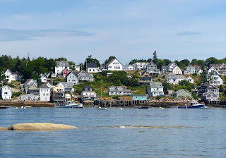
Penobscot Bay contains a number of islands and communities,
each with its own distinct personality.
We begin our exploration heading east from Rockland to North Haven on
Deer Island. We have a gusty downwind
sail into the Fox Island Thorofare, anchoring in nearby Seal Cove. It is peaceful in our anchorage, and we take
our dinghy into adjacent Perry Creek to explore this waterway that is almost
totally under a conservancy designation.
Birds soar overhead as the rocky treed and mossy shoreline passes by.
 |
| The interesting shoreline of Perry Creek |
 |
| Looking into Pery Creek at sunset as the fog begins to roll in |
When the wind settles we dinghy across the
Thorofare to take a walk through North Haven, a small community shared by
lobstermen and summer residents.
 |
| Looking over the docks at North Haven |
 |
| Stone wall with flower boarder in North Haven |
 |
| Looking west towards North Haven. A dramatic sunset with the outline of the Camden Hills in the background. |
Our next destination, further east, is Stonington on Deer
Island.
 |
| Hoses dot the hilly shore of Stonington |
This is definitely a lobstering
town although once its thriving stone quarries were the source of granite used
in many well-known buildings and bridges.
Now, the stone quarries are quiet, but remains can still be seen from the
water. A walk through Stonington gives
good evidence to the origins of the community’s name.
 |
| Rocks are everywhere |
Lobstering is a prosperous industry here; the
harbor is packed with boats and the lobster pounds are busy places at the end
of the day.
 |
| Lobster boats occupy this working harbor. |
Stonington has the benefit
of having a bridge from the island to the mainland, thus simplifying the
transport of the lobsters.
While we enjoy exploring Stonington, we decide to anchor
about a mile away in a cove formed by several islands including Devil’s Island
and the ever favorite Hell’s Half Acre. These are mainly unoccupied islands with
rounded granite rock shores and dense pine woods. At low tide (we have 12 foot tides during our
visit) the shoreline invites exploration.
 |
| A playground of rocks to explore |
Our cove and many other islands just
to our south form Merchants Row, a veritable trove of small rocky islets that
invite exploration by dinghy and kayak.
It is not unusual to see kayakers camping out on the unoccupied islands.
 |
| Looking over Merchants Row |
One evening, while enjoying a glass of wine
in the cockpit, we watch as a sailboat turns to enter our cove. Minutes later
we notice it has stopped moving and is now tilting. It takes a moment for the situation to sink
in, then we realize the boat has gone aground on a hidden ledge. We jump in the dinghy and simultaneously so
does a neighboring boater. Both of us race out to the stranded sailboat that,
with the rapidly falling tide, is perilously tilted. We run their halyard to our dinghy to further
tip the boat in order to free the keel while the other dinghy takes a tow
line. In a matter of seconds the boat is
free and bobbing properly on her lines.
The couple on board is in a state of shock as they realize they almost
lost their boat, but fortunately after checking the bilge, no damage is found.
 |
| Evening fog rolls into our anchorage |
From Stonington and the Deer Island Thorofare, we head
through Merchants Row to Isle au Haut, a new destination for us. Meaning “high island”, this sparsely populated
and remote island is home to a small fishing community, including noted author
Linda Greenlaw. Half the island is under
the auspices of Acadia National Park and includes hiking trails to the island
peaks. Few people visit Isle au Haut,
and we find only two rental moorings in the entire harbor.
 |
| A church and shoreside general store, along with a nearby tiny post office - that's about it for Isle au Haut infrastructure. |
To the south of the
harbor is an interesting lighthouse,
 |
| Robinson Point Light |
so we take a long walk on the empty island
roads to see it up close. The keeper’s
house has been turned into a bed and breakfast that exudes charm.
All along the road are wild blueberry bushes –
if only we had brought a container for picking.
Our final stop in this area is at Carver’s Harbor on the
south end of Vinalhaven Island. This is
the most active lobstering port we have ever visited. Boats come and go at all hours of the
day.
 |
| Lobster boats everywhere packed into the harbor |
Lobster pounds line the shore and
also operated at several floats within the harbor. It is a high energy place as fishermen rush
to get their catch accounted and loaded on the next ferry heading to
Rockland.
 |
| Pounds like this line the shore of the harbor |
 |
| Boats are unloaded at a frantic pace as there is always another waiting in line. It is not unusual to see women working alongside the men. |
And it is not a place
frequented by cruisers. Packed among the many moored lobster boats are two hard
to find rental moorings – you really have to know where to look. But despite the intensity of the community, we
have always found the locals to be friendly and welcoming. And it is home to
one of our favorite restaurants, The Haven.
Its popularity with residents of Vinalhaven Island is so great that
reservations are necessary several days in advance for their locally grown,
gourmet dinners.
At this point we head back to Rockland for a brief visit
before heading out to explore the northern end of Penobscot Bay.


